TORRANCE
ZAMPERINI FLD (TOA)(KTOA) 3 SW UTC–8(–7DT) N33°48.20′ W118°20.38′ 103 B NOTAM FILE TOA MON Airport
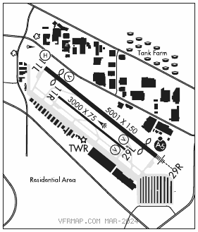
RWY 11L–29R: H5001X150 (ASPH–CONC) S–30, D–50, 2D–90 MIRL 0.3% up E IAP, AD
RWY 11L: VASI(V2L)–GA 3.5° TCH 10′. Thld dsplcd 541′. Trees.
RWY29R: MALSR. VASI(V4L)–GA 4.0° TCH 11′. Thld dsplcd 540′. Bldg. Rgt tfc.
RWY 11R–29L: H3000X75 (ASPH–CONC) S–28 MIRL
RWY 11R: Rgt tfc.
RWY 29L: REIL. VASI(V2L)–GA 4.0° TCH 29′. Bldg.
SERVICE: S4 FUEL 100LL OX 1, 2, 3, 4 LGT When ATCT clsd ACTVT MALSR Rwy 29R–CTAF, MIRL Rwy 11L–29R SS–SR, MIRL Rwy 11R–29L 1400–0400Z‡. ACTVT helipad perimeter lights–24 hrs–CTAF. VASI Rwy 29L oper consly. Rwy 29L VASI unusbl byd 2 deg right and 9 deg left of rwy cntrln.
NOISE: Noise sensitive area all quads. For noise abatement procs info ctc arpt Noise Abatement 310–784–7950. Certain tbjt acft permly excldd. Touch and go ldg and stop and go ldg and low apch ops ltd to 1600–0400Z‡ (taxi–back until 0600Z‡) wkdays and 1800–0100Z‡ Sat. No touch and go ldg and stop and go ldg and low apch ops and taxi–back ops on Sun and hol.
AIRPORT REMARKS: Attended 1400–0600Z‡. Fuel avbl 1500–0400Z‡. Numerous flocks of birds on and invof arpt. Be alert to psnl and eqpt oprg near all rwys and twys. Arpt CLOSED to depe 0600–1500Z‡ wkdays and 0600–1600Z‡ wkends and hol. No multi–engine simulated engine–out procedures authorized in tfc pat. At Twys Hotel and Charlie obs twy hold lines. All acft must hold btn the set of hold bars for the apch zone for Rwy 11R–29L.
AIRPORT MANAGER: 310-784-7914
WEATHER DATA SOURCES: LAWRS.
COMMUNICATIONS: CTAF 124.0 ATIS 125.6 310–534–2847 UNICOM 122.95
TOWER 133.075 (North) 124.0 (South) (1500–0400Z‡) GND CON 120.9
®SOCAL APP CON 124.3 (Rwy 11L, 11R) 127.2 (Rwy 29L/R)
®SOCAL DEP CON 124.3 (Rwy 29L, 29R) 127.2 (Rwy 11L/R)
CLEARANCE DELIVERY PHONE: For CD when ATCT clsd ctc SoCal Apch at 800-448-3724.
AIRSPACE: CLASS D svc 1500–0400Z‡; other times CLASS G.
VOR TEST FACILITY (VOT) 113.9
RADIO AIDS TO NAVIGATION: NOTAM FILE LAX.
LOS ANGELES (VH) (H) VORTACW 113.6 LAX Chan 83 N33°55.99′ W118°25.92′ 134° 9.0 NM to fld. 185/15E.
VOR unusable:
004°–014° byd 40 NM blo 12,000′
004°–014° byd 51 NM
015°–053° byd 40 NM
060°–081° byd 40 NM blo 4,500′
060°–081° byd 58 NM blo 14,000′
060°–081° byd 65 NM
082°–101° byd 40 NM
109°–115° byd 40 NM
138°–155° byd 40 NM
175°–205° byd 10 NM blo 3,000′
270°–277° byd 25 NM blo 8,000′
276°–329° byd 40 NM
277°–300° byd 10 NM blo 8,000′
277°–300° byd 28 NM blo 12,000′
341°–003° byd 40 NM
ILS/DME 111.9 I–TOA Chan 56 Rwy 29R.
COMM/NAV/WEATHER REMARKS: Twr sectorization is based on ctr of arpt parallel to Rwy 11–29 cntrln.
• • • • • • • • • • • • • • • • • •
HELIPAD H1: H110X110 (ASPH) PERIMETER LGTS
HELIPORT REMARKS: Helipad H1 yellow perimeter lgts.