TILLAMOOK (TMK)(KTMK) 3 S UTC–8(–7DT) N45°25.10′ W123°48.86′
39 B NOTAM FILE TMK
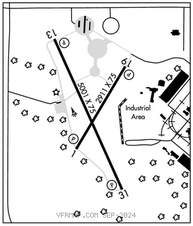
RWY 13–31: H5001X75 (ASPH) S–60, D–75, 2D–125 MIRL 0.4% up SE
RWY 13: REIL. PAPI(P2L)–GA 3.0° TCH 42′. Trees.
RWY 31: PAPI(P2L)–GA 3.5° TCH 40′. Tree.
RWY 01–19: H2911X75 (ASPH) S–40, D–46, 2D–67 MIRL
RWY 01: PAPI(P2L)–GA 4.0° TCH 45′.
RWY 19: PAPI(P2L)–GA 3.0° TCH 40′. Rgt tfc.
SERVICE: FUEL 100LL, JET A LGT ACTVT REIL Rwy 13; MIRL Rwy 13–31 and Rwy 01–19–CTAF. PAPI Rwys 13 and 31 and Rwys 01 and 19 oper cont.
AIRPORT REMARKS: Attended 1700–0100Z‡. Ultralight acft on and invof arpt. Ocnl flocks of birds on or near arpt. Rwy 01 markings fading and chipping. Rwy 19 markings fading and chipping. Rwy 13 nrs faded.
AIRPORT MANAGER: 503-842-2413
WEATHER DATA SOURCES: AWOS–3PT 120.0 (503) 842–8792.
COMMUNICATIONS: CTAF/UNICOM 122.8
®SEATTLE CENTER APP/DEP CON 124.2
CLEARANCE DELIVERY PHONE: For CD ctc Seattle ARTCC at 253-351-3694.
RADIO AIDS TO NAVIGATION: NOTAM FILE MMV.
NEWBERG (VH)(DH)VORW/DME 117.4 UBG Chan 121 N45°21.19′ W122°58.69′ 256° 35.6 NM to fld. 1443/21E.
VOR unusable:
095°–105° byd 40 NM
106°–120° byd 40 NM blo 7,800′
106°–120° byd 60 NM
135°–328° byd 40 NM
329°–346° byd 40 NM blo 5,000′
329°–346° byd 70 NM
347°–080° byd 40 NM