TRACY MUNI (TCY)(KTCY) 3 SW UTC–8(–7DT) N37°41.33′ W121°26.49′
194 B TPA–994(800) NOTAM FILE TCY
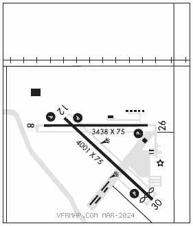
RWY 12–30: H4001X75 (ASPH) S–50, D–70, 2S–89, 2D–120 MIRL 0.3% up SE
RWY 12: REIL. PAPI(P2L)–GA 3.0° TCH 41′. Bldg.
RWY 30: REIL. PAPI(P2L)–GA 3.0° TCH 35′. Thld dsplcd 261′. Road.
RWY 08–26: H3438X75 (ASPH) S–50, D–70, 2S–89, 2D–120 MIRL 0.5% up W
RWY 08: REIL. PAPI(P2L)–GA 3.4° TCH 26′. Fence.
RWY 26: REIL. PAPI(P2L)–GA 3.0° TCH 20′. Road.
SERVICE: S4 FUEL 100LL, JET A OX 4 LGT ACTVT REIL Rwy 08, Rwy 12, Rwy 26, and Rwy 30; PAPI Rwy 08, Rwy 12 and Rwy 26; MIRL Rwy 08–26 and Rwy 12–30–CTAF. PAPI Rwy 30 is oprd at ngt by CTAF from SS to SR and is on drg dalgt hrs. Rwy 12 VGSI unusbl byd 5 degs left of cntrln.
AIRPORTREMARKS:Attended 1600–0200Z‡. Balloon and paraplane activity on the arpt. Two 150′ power plant stacks approximately 3 NM NW of arpt. Watch for psbl turb. Aerobatic area adjacent within 1 statute mile radius from 500 AGL–3000 MSL SR–SS.
AIRPORT MANAGER: (209) 831-6215
WEATHER DATA SOURCES: AWOS–3 118.375 (209) 831–4335.
COMMUNICATIONS: CTAF/UNICOM 123.075
®NORCAL APP/DEP CON 123.85
CLEARANCE DELIVERY PHONE: For CD ctc NorCal Apch at 916-361-0516.
RADIO AIDS TO NAVIGATION: NOTAM FILE MOD.
MODESTO (VH) (DH) VOR/DME 114.6 MOD Chan 93 N37°37.64′ W120°57.47′ 262° 23.3 NM to fld. 93/17E. Aerobatic acft wi an area defined as .5 NM rds of MOD 032028 (7.5 NM SW 022), blo 4800′, avoidance advised dly SR–SS
VOR unusable:
005°–009° byd 40 NM
028°–083° byd 40 NM
092°–097° byd 40 NM
112°–121° byd 40 NM
130°–145° byd 40 NM blo 4,000′
130°–145° byd 62 NM
146°–156° byd 40 NM
170°–185° byd 40 NM
186°–196° byd 40 NM blo 5,000′
186°–196° byd 49 NM
197°–338° byd 40 NM