WINSTON FLD (SNK)(KSNK) 2 SW UTC–6(–5DT) N32°41.60′ W100°57.03′
2430 B NOTAM FILE SNK
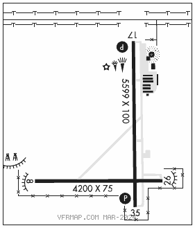
RWY 17–35: H5599X100 (ASPH) S–24 MIRL
RWY 17: REIL. PAPI(P4R)—GA 3.0° TCH 33′. Rgt tfc.
RWY 35: REIL. PAPI(P4L)—GA 3.0° TCH 30′.
RWY 08–26: H4200X75 (ASPH) S–24 1.3% up E
RWY 08: Trees. Rgt tfc.
SERVICE: FUEL 100LL, JET A1 LGT Dusk–Dawn. MIRL Rwy 17–35 preset low intst; to incr intst and actvt PAPI Rwys 17 and 35—CTAF. Rwy 35 PAPI unusbl byd 9 degs left and right of rwy cntrln.
AIRPORT REMARKS: Attended 1400–0000Z‡. Arpt unattended Thanksgiving, Christmas, and Easter.
AIRPORT MANAGER: 325-573-1122
WEATHER DATA SOURCES: AWOS–3 119.925 (325) 573–5724.
COMMUNICATIONS: CTAF/UNICOM 122.8
SNYDER RCO 122.45 (FORT WORTH RADIO)
®FORT WORTH CENTER APP/DEP CON 127.45
CLEARANCE DELIVERY PHONE: For CD if una to ctc on FSS freq, ctc Fort Worth ARTCC at 817-858-7584.
RADIO AIDS TO NAVIGATION: NOTAM FILE BPG.
BIG SPRING (VL) (H) VORTACW 117.2 BGS Chan 119 N32°23.14′ W101°29.02′ 045° 32.7 NM to fld. 2670/11E.
SNYDER NDB (MHW) 359 SDR N32°42.08′ W100°56.77′ at fld. 2434/8E. NOTAM FILE FTW.