CHESTER (SNC)(KSNC) 3 SW UTC–5(–4DT) N41°23.02′ W72°30.35′
416 B NOTAM FILE SNC
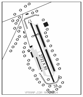
RWY 17–35: H2722X50 (ASPH) S–8.5 MIRL 0.5% up S
RWY 17: REIL. Thld dsplcd 559′. Tree.
RWY 35: REIL.
SERVICE: S4 FUEL 100LL LGT SS–SR. Rotating bcn opr 24 hrs.
AIRPORT REMARKS: Attended Apr–Oct 1400–0100Z‡, Nov–Mar 1400–2300Z‡. Self svc fuel avbl with credit card. Rwy 17 dsplcd thld marked but not lgtd, dsplcd thld 5′ higher than end of rwy. Rwy 17–35 non–std MIRL fixtures/cones.
AIRPORT MANAGER: 860-718-2109
WEATHER DATA SOURCES: AWOS–3 118.325 (860) 526–1551.
COMMUNICATIONS: CTAF/UNICOM 122.725
RCO 122.25 (BRIDGEPORT RADIO)
®NEW YORK APP/DEP CON 124.075
CLEARANCE DELIVERY PHONE: For CD ctc New York Apch at 516-683-2449.
RADIO AIDS TO NAVIGATION: NOTAM FILE BDR.
MADISON (L) (L) VORW/DME 110.4 MAD Chan 41 N41°18.83′ W72°41.53′ 077° 9.4 NM to fld. 216/13W.
DME unusable:
330°–090° byd 30 NM blo 4,000′