SANTA MARIA PUB/CAPT G ALLAN HANCOCK FLD (SMX)(KSMX) 3 S UTC–8(–7DT) N34°54.00′
W120°27.49′ 261 B TPA–See Remarks Class I, ARFF Index B NOTAM FILE SMX
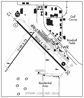
RWY 12–30: H8004X150 (ASPH–GRVD) S–75, D–181, 2S–175, 2D–400 PCN 56 F/B/X/U HIRL
RWY 12: MALSR. PAPI(P4R)–GA 3.0° TCH 55′. RVR–T Rgt tfc. 0.5% up.
RWY 30: PAPI(P4R)–GA 3.6° TCH 46′. RVR–R Trees. 0.6% down.
RWY 02–20: H5199X75 (ASPH) S–70, D–90, 2S–114, 2D–150 PCN 6 F/B/Y/U 0.3% up N
RWY 02: Rgt tfc.
RWY 20: Trees.
RUNWAY DECLARED DISTANCE INFORMATION
RWY 02: TORA–5199 TODA–5199 ASDA–5199 LDA–5199
RWY 12: TORA–8004 TODA–8004 ASDA–8004 LDA–8004
RWY 20: TORA–5199 TODA–5199 ASDA–5199 LDA–5199
RWY 30: TORA–8004 TODA–8004 ASDA–8004 LDA–8004
SERVICE: S4 FUEL 100LL, JET A LGT When ATCT clsd ACTVT MALSR Rwy 12, PAPI Rwy 30, HIRL Rwy 12–30, twy lights–CTAF. PAPI Rwy 12 oper consly.
AIRPORT REMARKS: Attended 1400–0600Z‡. Acft fuel servicing avbl 129.975 or 122.950. Self svc fuel 100LL avbl 24 hrs located north of twr. CLSD to suppll Part 121 and P135 acr ops excp 24 hrs PPR, call amgr (805) 922–1726 wkdays 1600–0100Z‡. Rwy 02–20 not avbl for sked acr opns with more than 9 psgr seats or unsked acr at least 31 psgr seats. Numerous birds on and invof arpt. Parallel lgtd road less than 1/4 mile NW of Rwy 12–30. Calm wind less than 8 knots use Rwy 30. No touch and go opr landing practice or practice instrument approaches 0600–1500Z‡. TPA–1261(1000), turbojet and purejet 1761(1500). Rwy 02–20 not avbl for air carrier use. Transient pilots remain clear of commercial ramp and terminal. Run–up apron Rwy 30 gross weight limit 110,000 pounds dual wheel, 110,000 pounds dual wheel. Portions of Twy J not visible from twr and unlighted.
AIRPORT MANAGER: 805-922-1726
WEATHER DATA SOURCES: ASOS 121.15 (805) 928–0384. ASOS broadcasts over ATIS
COMMUNICATIONS: CTAF 118.3 ATIS 121.15 (805) 347–9136 UNICOM 122.95
GUADALUPE RCO 122.1R 113.05T (HAWTHORNE RADIO)
®SANTA BARBARA APP/DEP CON 124.15 (1400–0700Z‡)
®L.A. CENTER APP/DEP CON 119.05 (0700–1400Z‡)
TOWER 118.3 (1400–0400Z‡) GND CON 121.9
AIRSPACE: CLASS D svc 1400–0400Z‡; other times CLASS G.
RADIO AIDS TO NAVIGATION: NOTAM FILE HHR.
MORRO BAY (VL) (L)VORTACW 112.4 MQO Chan 71 N35°15.14′ W120°45.57′ 129° 25.8 NM to fld. 1463/16E.
VOR unusable:
092°–100° byd 40 NM
193°–205° byd 40 NM
290°–315° byd 7 NM blo 4,000′
297°–315° byd 13 NM blo 7,000′
315°–090° byd 7 NM blo 7,000′
350°–082° byd 40 NM
GUADALUPE (VL) VOR 113.05 GLJ N34°57.14′ W120°31.29′ 119° 4.4 NM to fld. 138/16E.
VOR unusable:
092°–100° byd 40 NM
119°–124° byd 40 NM
125°–135° byd 40 NM blo 5,000′
125°–135° byd 43 NM
136°–245° byd 40 NM
295°–300° byd 40 NM
306°–085° byd 40 NM
ILS/DME 108.9 I–SMX Chan 26 Rwy 12. Class IE. LOC, GS, and DME unmonitored when ATCT clsd. OM unmonitored. LOC front course unusable byd 25° right of course. Localizer backcourse unusable byd 25° right of course; byd 9 NM blw 3,000′; byd 12 NM. DME backcourse unusable byd 9 NM blw 3,000′.