SALINA RGNL (SLN)(KSLN) P (ARNG) 3 SW UTC–6(–5DT) N38°47.44′ W97°39.13′
1288 B ARFF Index–See Remarks NOTAM FILE SLN MON Airport
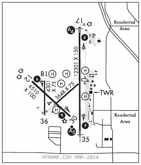
RWY 17–35: H12301X150 (ASPH–CONC) S–75, D–200, 2D–360, 2D/2D2–600 PCN 75 R/C/W/U HIRL
RWY 17: MALS. PAPI(P4L)–GA 3.0° TCH 52′.
RWY 35: MALSR. PAPI(P4R)–GA 3.0° TCH 48′. Ground.
RWY 12–30: H6510X100 (ASPH) S–55, D–68, 2D–125 PCN 23 R/C/X/U MIRL
RWY 12: PAPI(P4L)–GA 3.0° TCH 45′.
RWY 30: PAPI(P4L)–GA 3.0° TCH 45′.
RWY 18–36: H4301X75 (ASPH) S–30 PCN 11 F/C/Y/U
RWY 04–22: H3648X75 (ASPH) S–100, D–135, 2D–230 PCN 5 F/C/Y/U 0.5% up SW
RWY 22: Bldg.
RUNWAY DECLARED DISTANCE INFORMATION
RWY 04: TORA–3648 TODA–3648 ASDA–3648 LDA–3648
RWY 12: TORA–6510 TODA–6510 ASDA–6510 LDA–6510
RWY 17: TORA–12300 TODA–12300 ASDA–12300 LDA–12300
RWY 18: TORA–4300 TODA–4300 ASDA–4300 LDA–4300
RWY 22: TORA–3648 TODA–3648 ASDA–3648 LDA–3648
RWY 30: TORA–6510 TODA–6510 ASDA–6510 LDA–6510
RWY 35: TORA–12300 TODA–12300 ASDA–12300 LDA–12300
RWY 36: TORA–4300 TODA–4300 ASDA–4300 LDA–4300
SERVICE: S4 FUEL 100LL, JET A OX 1 LGT When twr clsd ACTIVATE MIRL Rwy 12–30, PAPI Rwy 12 and Rwy 30, HIRL Rwy 17–35, MALS and PAPI Rwy 17 and Rwy 35; MALSR Rwy 35–CTAF MILITARY– JASU 2(A/M32–95) 2(AM32–60B) 1(A/M32–86D) FUEL A+ (C785–825–6261) (NC–100LL, A) FLUID LPOX HPOX LPNIT LOX (72 hr notice) De–icing svc Type I and Type 4 OIL 0–128–148 avbl quart cans.
NOISE: Noise abatement: Heavy and mil acft TPA at 2,800 MSL or above.
AIRPORT REMARKS: Attended continuously. 100LL self svc fueling station located south of Kansas ANG. No line of sight, all rwys due to gradient, topography and trees. Seasonal mowing ops adjacent to rwys and twys. Calm wind Rwy 35. Rwy 04–22 and Rwy 18–36 unavbl for use by acft with more than 9 passenger seats. Class I, ARFF Index A. PPR 24 hrs for unsked acr opns with more than 30 psger seats call AMGR 785–827–3914. ARFF Index B provdd Sun–Sat 1200–0400Z‡ (0600–2200 local). Index E avbl upon req. Btn 0001–0459 local ACFT opns involving acft with more than 9 psgr seats are not auth in excess of 15 mins bfr or aft sked arr or dep times w/o prior coord with amgr to confirm that ARFF svcs are avbl prior to lndg or tkof, call arpt manager 785–827–3914. Gnd support and logistics equip avbl incl tugs, bobtails, tow bars and airstairs. ARFF Index: Rwy 04–22 and Rwy 18–36 not avbl for scheduled acr opns with more than 9 psgr seats or unscheduled acr at least 31 psgr seats.
MILITARY REMARKS: ARNG Opr 1300–2300Z‡ Tue–Fri; ocnl Sat exc hol. Ltd maint UH–60. ARNG, AR and A ctc ARNG OPS prior to ldg or call 785–827–3914 for liason. Ramp space avbl to accommodate up to 80 fighters. Smoky Hill ANG Weapons Range 16 NM to the southwest. Coord range time at dsn 743–7600 ext 148. Transient army acft ctc Salina Guard OPS on 229.8 or 34.10 sc red. Limited UH–60 svc and maintenance avbl. TRAN ALERT Trans svc avbl at FBO. Logistical svc avbl for dets and RON at FBO. Ltd to fuel, oil, O2, parking and hangar. DOD contractor at C800–748–8260, C785–825–6261.
AIRPORT MANAGER: 785-827-3914
WEATHER DATA SOURCES: ASOS 120.15 (785) 823–3402. LAWRS 1900–0500Z‡.
COMMUNICATIONS: CTAF 119.3 ATIS 120.15 UNICOM 122.95
RCO 122.4 (WICHITA RADIO)
®KANSAS CITY CENTER APP/DEP CON 134.9
TOWER 119.3 124.35 (1300–0500Z‡) GND CON 121.9
CLEARANCE DELIVERY PHONE: For CD if una to ctc on FSS freq, ctc Kansas City ARTCC at 913-254-8508.
AIRSPACE: CLASS D svc 1300–0500Z‡; other times CLASS E.
RADIO AIDS TO NAVIGATION: NOTAM FILE SLN.
(VH) (H) VORTACW 117.1 SLN Chan 118 N38°55.51′ W97°37.28′ 183° 8.2 NM to fld. 1316/7E.
VOR unusable:
006°–016° byd 40 NM blo 6,000′
006°–016° byd 56 NM
017°–027° byd 40 NM
028°–039° byd 40 NM blo 6,000′
028°–039° byd 61 NM
130°–140° byd 40 NM
285°–005° byd 40 NM
315°–016° byd 15 NM blo 6,000′
DME unusable:
300°–042° byd 15 NM blo 6,000′
FLORY NDB (LOMW) 344 SL N38°40.89′ W97°38.70′ 350° 6.5 NM to fld. 1318/7E.
ILS 108.9 I–SLN Rwy 35. Class IE. LOM FLORY NDB. LOC unusable byd 25° left of course. Unmonitored when twr clsd.
COMM/NAV/WEATHER REMARKS: Freq 121.5 not avbl at twr.
• • • • • • • • • • • • • • • • • •
HELIPAD H1: H57X57 (CONC)
HELIPAD H2: H29X28 (ASPH)
HELIPAD H3: H30X30 (CONC)
HELIPAD H4: H57X43 (ASPH)
HELIPAD H5: H57X57 (CONC)
HELIPAD H6: H29X29 (CONC)
HELIPORT REMARKS: H1 ingress/egress 070 deg through 040 deg to avoid ctl twr. All helipads dalgt use only. H3, H4, H5, H6 used extensively for trng. H2, H3 ltd to 6,000 lbs, H4, H5 ltd to 25,000 lbs.