CHEBOYGAN CO (SLH)(KSLH) 2 W UTC–5(–4DT) N45°39.22′ W84°31.16′
640 B NOTAM FILE SLH
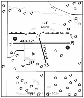
RWY 10–28: H4004X75 (ASPH) S–23, D–34, 2D–60 MIRL 0.3% up W
RWY 10: REIL. PAPI(P2L)—GA 4.0° TCH 40′. Road.
RWY 28: REIL. PAPI(P2L)—GA 4.0° TCH 25′. Trees.
RWY 17–35: H1874X60 (ASPH) MIRL
RWY 35: Trees.
SERVICE: S4 FUEL 100LL, JET A+ LGT ACTIVATE REIL Rwy 10 and Rwy 28; PAPI Rwy 10 and Rwy 28; MIRL Rwy 10–28 and Rwy 17–35 — 122.5.
AIRPORT REMARKS: Attended 1300–2100Z‡. Unatndd Christmas, Easter and Thanksgiving. Deer and birds on and invof arpt. After hrs trml bldg access: press 5, then 3 & 2 simul, then 1. 100LL avbl H24 self svc; for Jet A after hrs call 989–464–6887 or 616–443–1010 subj call in fee.
AIRPORT MANAGER: 231-627-5571
WEATHER DATA SOURCES: AWOS–3 118.175 (231) 627–4671.
COMMUNICATIONS: CTAF/UNICOM 122.8
®MINNEAPOLIS CENTER APP/DEP CON 134.6
CLEARANCE DELIVERY PHONE: For CD ctc Minneapolis ARTCC at 651-463-5588.
RADIO AIDS TO NAVIGATION: NOTAM FILE PLN.
PELLSTON (L) (L) VORTACW 111.8 PLN Chan 55 N45°37.84′ W84°39.85′ 083° 6.3 NM to fld. 836/6W.
VOR unusable:
301°–339°
GCP has azm only, no DME at GCP