SALEM
MCNARY FLD (SLE)(KSLE) P (ARNG) 2 SE UTC–8(–7DT) N44°54.57′ W123°00.15′ 213 B Class I, ARFF Index B NOTAM FILE SLE MON Airport
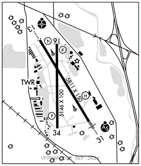
RWY 13–31: H5811X150 (ASPH–GRVD) S–105, D–147, 2S–154 PCN 41 F/C/X/T HIRL 0.3% up SE
RWY 13: ODALS. REIL. VASI(V4L)–GA 3.0° TCH 50′. RVR–R Road.
RWY 31: MALSR. RVR–T Tree.
RWY 16–34: H5146X100 (ASPH–GRVD) S–39.5, D–52 PCN 15 F/D/X/T MIRL 0.3% up S
RWY 16: REIL. PAPI(P4L)–GA 3.0° TCH 38′. Road.
RWY 34: REIL. PAPI(P4L)–GA 4.0° TCH 42′. Tree.
LAND AND HOLD–SHORT OPERATIONS
LDG RWY HOLD–SHORT POINT AVBL LDG DIST
RWY 31 16–34 3150
RWY 34 13–31 3050
RUNWAY DECLARED DISTANCE INFORMATION
RWY 13: TORA–5811 TODA–5811 ASDA–5811 LDA–5811
RWY 16: TORA–5145 TODA–5145 ASDA–5145 LDA–5145
RWY 31: TORA–5811 TODA–5811 ASDA–5811 LDA–5811
RWY 34: TORA–5145 TODA–5145 ASDA–5145 LDA–5145
SERVICE: S4 FUEL 100LL, JET A OX 1, 3 LGT When ATCT clsd ACTVT MALSR Rwy 31; ODALS Rwy 13; REILS Rwy 13, Rwy 16–34; HIRL Rwy 13–31, MIRL Rwy 16–34–CTAF. REILS Rwy 16 OTS indefly: PAPI Rwy 16 and Rwy 34 OTS indefly; bcn OTS indefly.
MILITARY– FUEL (NC–100LL–Self svc avbl H24. A–Avbl after bus hr with PN C503–508–4178/593–364–0111.)
NOISE: Ns abtmt procs in efct. Avd ovr flt of srng resl areas when poss.
AIRPORT REMARKS: Attended Mon–Fri 1500–0300Z‡, Sat–Sun 1500–0100Z‡. Bird haz, heavy concentration waterfowl adjacent to arpt and apchs to all rwys. Flocks of geese concentrated transiting Class D airspace at tfc pat alt Oct–May. Self fueling, 100LL only, avbl 24 hrs a day. Jet A avbl aft nml bus hrs with advnd notice at 503–508–4178 or 503–364–4158. Airfield conds not mntd btn 1600–0800Z‡ and all times Sat and Sun. Arpt clsd aft heavy snwfl. Rsg trrn and trees W and S of arpt, inclg extd cntrln of Rwy 34. Trees on extd cntrln of Rwy 16. Ngt ops not rcmd both rwys. PPR for unscheduled air carrier ops with more than 30 pax seats, call arpt mgr on 503–588–6314. PPR rqd for prkg acft on acr ramp. Call amgr 503–588–6314. Acft prkg on S G/A ramp ltd to acft under 12,500 lbs. Twy A from Twy L to Twy L9 not visible from twr.
AIRPORT MANAGER: (503) 589-2057
WEATHER DATA SOURCES: ASOS 124.55 (503) 371–1062.
COMMUNICATIONS: CTAF 119.1 ATIS 124.55 UNICOM 122.95
SALEM RCO 122.6 (MC MINNVILLE RADIO)
®SEATTLE CENTER APP/DEP CON 125.8
SALEM TOWER 119.1 (1500–0500Z‡) GND CON 121.9
CLEARANCE DELIVERY PHONE: For CD if una to ctc on FSS freq, ctc Seattle ARTCC at 253-351-3694.
AIRSPACE: CLASS D svc 1500–0500Z‡; other times CLASS E.
RADIO AIDS TO NAVIGATION: NOTAM FILE MMV.
NEWBERG (VH) (DH) VORW/DME 117.4 UBG Chan 121 N45°21.19′ W122°58.69′ 161° 26.6 NM to fld. 1443/21E.
VOR unusable:
095°–105° byd 40 NM
106°–120° byd 40 NM blo 7,800′
106°–120° byd 60 NM
135°–328° byd 40 NM
329°–346° byd 40 NM blo 5,000′
329°–346° byd 70 NM
347°–080° byd 40 NM
TURNO NDB (LOM) 266 SL N44°50.85′ W122°57.06′ 312° 4.3 NM to fld.
ILS/DME 110.3 I–SLE Chan 40 Rwy 31. Class IT. LOM TURNO NDB. • • • • • • • • • • • • • • • • • •
HELIPAD H1: H37X37 (CONC)