BEAVER ISLAND (SJX)(KSJX) 4 SW UTC–5(–4DT) N45°41.53′ W85°34.00′
670 B NOTAM FILE SJX
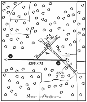
RWY 09–27: H4299X75 (ASPH) MIRL
RWY 09: REIL. PAPI(P4L)—GA 3.0° TCH 24′.
RWY 27: REIL. PAPI(P4L)—GA 4.0° TCH 40′. Tree.
RWY 14–32: 3278X120 (TURF)
RWY 14: Thld dsplcd 522′. Trees.
RWY 32: Thld dsplcd 571′. Road.
RWY 05–23: 2054X120 (TURF)
RWY 05: Trees.
RWY 23: Thld dsplcd 763′. Trees.
SERVICE: FUEL 100LL LGT Actvt REIL Rwy 09 and 27; PAPI Rwy 09 and 27; MIRL Rwy 09–27—CTAF.
AIRPORT REMARKS: Attended 1300–2200Z‡. Unatndd Thanksgiving & Christmas. Deer and birds on and invof arpt. Rwys 05–23 and 14–32 CLOSED Nov–Apr & when snow covd. Rwy 05 mkg type: 3 ft yellow cones. Rwy 14 mkg type: 3 ft yellow cones; dthr mkd with three 3 cones each side. Rwy 23 mkg type: 3 ft yellow cones; dthr mkd with three 3 cones each side. Rwy 32 mkg type: 3 ft yellow cones; dthr mkd with three 3 cones each side.
AIRPORT MANAGER: 231-237-9482
WEATHER DATA SOURCES: AWOS–3 118.075 (231) 448–3081.
COMMUNICATIONS: CTAF/UNICOM 122.8
®MINNEAPOLIS CENTER APP/DEP CON 134.6
CLEARANCE DELIVERY PHONE: For CD ctc Minneapolis ARTCC at 651-463-5588.
RADIO AIDS TO NAVIGATION: NOTAM FILE PLN.
PELLSTON (L) (L) VORTACW 111.8 PLN Chan 55 N45°37.84′ W84°39.85′ 282° 38.2 NM to fld. 836/6W.
VOR unusable:
301°–339°
GCP has azm only, no DME at GCP