PAWTUCKET
NORTH CENTRAL STATE (SFZ)(KSFZ) 3 E UTC–5(–4DT) N41°55.25′ W71°29.49′ 441 B LRA NOTAM FILE SFZ
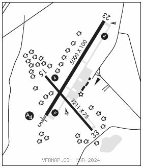
RWY 05–23: H5000X100 (ASPH) S–30, D–60 HIRL
RWY 05: MALS. PAPI(P4R)–GA 3.0° TCH 52′. Trees.
RWY 23: REIL. PAPI(P4L)–GA 3.0° TCH 35′. Trees.
RWY 15–33: H3211X75 (ASPH) S–12.5 MIRL 0.5% up SE
RWY 15: REIL. PAPI(P4L)–GA 3.5° TCH 35′. Trees.
RWY 33: REIL. Trees.
SERVICE: S4 FUEL 100LL, JET A, A+ LGT ACTVT MALS Rwy 05; REIL Rwy 15, 23 and 33; PAPI Rwy 05, 15 and 23; HIRL Rwy 05–23; MIRL Rwy 15–33; twy lgts –CTAF.
NOISE: Noise abatement procedures in effect, contact airport manager.
AIRPORTREMARKS:Attended 1200–2200Z‡ Sun–Sat. Parachute Jumping. Birds and wildlife on and invof arpt. Ap wildlife haz deer act increased hn. Seasonal skydiving northeast side of afld. Seasonal gldr ops invof arpt SR–SS. Rwy conds may not be mnt or rprtd when ap is unattended. Ctc RI ap corporation ops 401–691–2265. Lgtd 250 ft MSL tower 3.4 miles SE. +50′ drop–off 250′ from Rwy 05 end, +40′ drop–off 250′ from Rwy 23 end. Nmrs unlgtd obstns up to 150 ft AGL srndg airfield. Overnight parking fee. Ldg fee for commercial acft and non–Rhode Island registered acft.
AIRPORT MANAGER: 401-691-2000
WEATHER DATA SOURCES: AWOS–3PT 120.775 (401) 334–0324.
COMMUNICATIONS: CTAF/UNICOM 123.075
®PROVIDENCE APP/DEP CON 123.675 (Sun–Fri 1030–0530Z‡ Sat 1030–0500Z‡ other times ctc)
®BOSTON CENTER APP/DEP CON 124.85
CLNC DEL 124.35
CLEARANCE DELIVERY PHONE: For CD when Apch clsd ctc Boston ARTCC at 603-879-6859.
RADIO AIDS TO NAVIGATION: NOTAM FILE PVD.
PROVIDENCE (H)(DH) VORW/DME 115.6 PVD Chan 103 N41°43.46′ W71°25.78′ 001° 12.1 NM to fld. 49/14W.
VOR unusable:
085°–105° byd 12 NM blo 5,500′
085°–105° byd 8 NM blo 3,000′
106°–294° byd 30 NM blo 3,000′
295°–330° byd 30 NM blo 6,000′
331°–084° byd 30 NM blo 3,000′
DME unusable:
085°–105° byd 12 NM blo 5,500′
085°–105° byd 8 NM blo 3,000′
106°–152° byd 11 NM blo 2,000′
106°–152° byd 20 NM blo 4,000′
153°–294° byd 30 NM blo 3,000′
295°–330° byd 30 NM blo 6,000′
331°–084° byd 30 NM blo 3,000′
PUTNAM (H) (H) VORW/DME 117.4 PUT Chan 121 N41°57.33′ W71°50.65′ 111° 15.9 NM to fld. 652/14W. NOTAM FILE BDR.
DME unusable:
265°–301° byd 36 NM blo 3,000′
LOC/DME 111.9 I–SFZ Chan 56 Rwy 05. LOC unmonitored.