SAN DIEGO INTL (SAN)(KSAN) P (CG) 2 W UTC–8(–7DT) N32°44.01′ W117°11.38′
17 B AOE Class I, ARFF Index D NOTAM FILE SAN
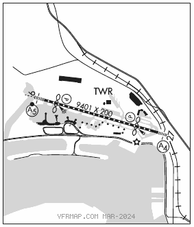
RWY 09–27: H9401X200 (ASPH–CONC–GRVD) S–100, D–150, 2D–250, 2D/2D2–720 PCN 75 F/A/W/T HIRL CL
RWY 09: MALSR. TDZL. PAPI(P4L)–GA 3.3° TCH 76′. RVR–TR Thld dsplcd 1000′. Tree.
RWY 27: MALS. TDZL. PAPI(P4R)–GA 3.5° TCH 66′. RVR–TR Thld dsplcd 1810′. Sign. Rgt tfc.
RUNWAY DECLARED DISTANCE INFORMATION
RWY 09: TORA–8280 TODA–9401 ASDA–8280 LDA–7280
RWY 27: TORA–9401 TODA–9401 ASDA–9401 LDA–7591
ARRESTING GEAR/SYSTEM
RWY 27: EMAS
SERVICE: S2 FUEL 100LL, JET A OX 1, 2 LGT Twy C edge lgts OTS indef. Rwy 27 PAPI unusable byd 5° left and right of centerline.
MILITARY– A–GEAR Rwy 27 EMAS 315′ x 218′. FUEL (NC–100LL, A)
FLUID OX.
NOISE: Dep curfew in efct. Deps prohibited 0730–1430Z‡. Sgfnt fines. Med flts exempt with form. Noise ofc 619–400–2660. NOTE: See Special Notices–Aircraft Noise Prohibitions/Restrictions.
AIRPORT REMARKS: Attended continuously. Intermittent presence of birds on and invof arpt. Pilots are required to ctc gnd controller prior to pushback, tow out and taxi for tfc advisories. Ultralight acft prohibited on arpt. Practice approaches and touch and go landings prohibited. ASDE–X in use. Operate transponders with altitude reporting mode and ADS–B (if equipped) enabled on all airport surfaces. Taxiing acft are prohibited from passing to the south of acft located on Twy B into alley located between Gates 7 and 14. Taxiing acft shall follow lead–in lines until the nose wheel of the acft has entered the non–movement area of the alley. Rwy 09–27 FAA gross weight strength DC10–10 410; DC10–30 530; L–1011 430; B747 720. 747 and larger acft are prohibited from making intersection tkfs. To reduce jet blast impact at north end of Twy F acft will not start engine until 800′ from north end of Twy F, abeam the second parking pad. Aircraft crossing Rwy 09–27 on Twy C6, hold short of Twy C6 facing west on Taxiway C, parallel to runway. In the event of a diversion or irregular opr events, acft opr ctc the arpt duty manager 619–400–2710 for PPR due to limitations associated with handling diverted flights. Limitations include rstd gate space, customs svcs as well as acft servicing and parking. For access to/fr Terminal 2 : Gates 23, 25, 27, 29, 31, 33–51 and the island and west RON parking ramps, ctc ramp ctl on 129.775 sry 131.975 fr 1400–0800Z‡, from 0800–1400Z‡ ctc ground ctl on 123.9. Rwy status lgts in operation. Taxilane A rstd to acft with wingspans of 135′ or less. Acft with wingspans greater than 171′ rstd from using Twy D south of Twy B, and when exiting Rwy 09 westbound on Twy B. Outboard engines of four–engine acft are to be kept at idle power for all ground maneuvering. Cross–bleed engine starts permitted only on parallel twy with acft aligned on twy centerline. Due to PAEW on Rwy 09–27, 30 minute PPR 0830–1230Z‡ for all landings and departures call 619–400–2710. 30 minute PPR 619–400–2710 for acft with over 171′ wingspan. Military acft on official business only ctc arpt ops at 619–400–2710 for PPR. Flight Notification Service (ADCUS) available. NOTE: See Special Notices–Aircraft Noise Prohibitions/Restrictions.
AIRPORT MANAGER: 619-400-2718
WEATHER DATA SOURCES: ASOS (619) 296–8934
COMMUNICATIONS: D–ATIS 134.8 619–298–0997
MONTGOMERY RCO 122.2 (SAN DIEGO RADIO)
®SOCAL APP/DEP CON 124.35 (East), 119.6 (West)
LINDBERGH TOWER 118.3 GND CON 123.9 CLNC DEL 125.9
CPDLC (LOGON KUSA)
PDC
AIRSPACE: CLASS B See VFR Terminal Area Chart.
VOR TEST FACILITY (VOT) 109.0
RADIO AIDS TO NAVIGATION: NOTAM FILE SAN.
MISSION BAY (VH) (H) VORTACW 117.8 MZB Chan 125 N32°46.93′ W117°13.53′ 133° 3.4 NM to fld. 1015E.
VOR unusable:
026°–088° byd 40 NM
090°–100° byd 28 NM
100°–130° byd 17 NM
130°–190° byd 14 NM
190°–219° byd 20 NM
215°–241° byd 40 NM
242°–252° byd 40 NM blo 8,000′
242°–252° byd 55 NM blo 18,000′
253°–288° byd 40 NM
289°–299° byd 40 NM blo 4,500′
289°–299° byd 49 NM
300°–333° byd 40 NM
308°–350° byd 20 NM blo 8,000′
347°–351° byd 40 NM
352°–002° byd 40 NM blo 7,000′
352°–002° byd 52 NM
TACAN AZIMUTH unusable:
310°–350° byd 15 NM blo 6,000′
310°–350° byd 30 NM blo 10,000′
DME unusable:
310°–350° byd 20 NM blo 6,000′
310°–350° byd 30 NM blo 10,000′
ILS/DME 111.55 I–SAN Chan 52(Y) Rwy 09. Class IE. Autopilot coupled approaches NA below 530′ MSL.
LOC/DME 110.9 I–UBR Chan 46 Rwy 27. LOC unusable byd 25° right of course.