RIVERSIDE MUNI (RAL)(KRAL) 4 SW UTC–8(–7DT) N33°57.11′ W117°26.71′
819 B TPA–See Remarks NOTAM FILE RAL MON Airport
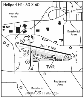
RWY 09–27: H5401X100 (ASPH) S–48, D–70, 2S–89, 2D–110 MIRL 1.1% up E
RWY 09: PAPI(P4L)–GA 3.0° TCH 41′.
RWY 27: PAPI(P4L)–GA 3.0° TCH 40′. Ground.
RWY 16–34: H2850X50 (ASPH) S–40, D–50, 2D–80 MIRL 0.8% up N
RWY 16: Rgt tfc.
RWY 34: PAPI(P2L)–GA 3.0° TCH 36′.
SERVICE: S4 FUEL 100LL, JET A OX 1, 2, 3, 4 LGT ACTIVATE MIRL Rwy 09–27 and Rwy 16–34, twy lgts, helipad perimeter lgts–CTAF. PAPI Rwy 09, Rwy 27, and Rwy 34 opr continuously.
AIRPORT REMARKS: Attended Mon–Fri 1500–0100Z‡, Sat–Sun 1400–0000Z‡. For fuel after hrs call 951–321–0091. Numerous power lines 1780′–2887′ N of Rwy 16 thld at or blo 80′ AGL. Rwy 27 –20 ft ditch 50 ft fm Rwy 27 thld. Rwy 27 dep: For noise mgmt, after dep turn right 10°; assume crs after rchg 2139(1500). Rwy 16–34 limited by arpt operator to 12500 lbs single wheel gear. Power plant 3000′ N of Rwy 16 thld producing thermal plume, avoidance advised. TPA–1819(1000) light acft, 2319(1500) jet and all other acft. Acft departing Rwy 09 and Rwy 27 not visible to acft at other end of rwy. S 1400′ of Rwy 34 and Twy J and S 500′ of Twy B not visible from the twr. Twy L not visible from twr. Twy E steep slope. For Noise Mgmt: Not turns bfr arpt bdry and 2139(1500). No high power eng maint runs btn 2200–0700 lcl. Turbine eng acft: Preferred rolling tkof for noise mgmt.
AIRPORT MANAGER: 951-351-6113
WEATHER DATA SOURCES: ASOS 128.8 (951) 352–4392. LAWRS.
COMMUNICATIONS: CTAF 121.0 ATIS 128.8 951–688–7257 UNICOM 122.95
RCO 122.2 (RIVERSIDE RADIO)
®SOCAL APP/DEP CON 135.4
TOWER 121.0 (1500–0400Z‡) GND CON 124.12
CLEARANCE DELIVERY PHONE: For CD when ATCT clsd ctc SoCal Apch at 800-448-3724.
AIRSPACE: CLASS D svc 1500–0400Z‡; other times CLASS G.
RADIO AIDS TO NAVIGATION: NOTAM FILE RAL.
PARADISE (VH) (H) VORTACW 112.2 PDZ Chan 59 N33°55.10′ W117°31.80′ 050° 4.7 NM to fld. 1432/15E.
TACAN AZIMUTH unusable:
130°–145° byd 25 NM blo 5,000′
145°–190° blo 8,000′
190°–230° blo 10,000′
310°–325° byd 35 NM blo 10,900′
325°–345° byd 25 NM blo 11,500′
345°–360° byd 35 NM blo 10,500′
VOR unusable:
000°–006° byd 40 NM
007°–017° byd 40 NM blo 10,000′
007°–017° byd 48 NM
010°–015° byd 20 NM blo 10,000′
018°–040° byd 40 NM
041°–051° byd 40 NM blo 25,000′
052°–065° byd 40 NM
080°–088° byd 40 NM
108°–118° byd 40 NM blo 9,000′
108°–118° byd 53 NM
119°–144° byd 40 NM blo 12,000′
119°–144° byd 85 NM
130°–145° byd 25 NM blo 5,000′
145°–190° blo 8,000′
145°–190° byd 25 NM blo 10,000′
145°–190° byd 39 NM blo 13,500′
190°–230° blo 10,000′
285°–300° byd 40 NM
301°–311° byd 40 NM blo 18,000′
310°–325° byd 35 NM blo 10,900′
325°–345° byd 25 NM blo 11,500′
345°–360° byd 35 NM blo 10,500′
DME unusable:
130°–145° byd 25 NM blo 5,000′
145°–190° blo 8,000′
190°–230° blo 10,000′
310°–325° byd 35 NM blo 10,900′
325°–345° byd 25 NM blo 11,500′
345°–360° byd 35 NM blo 10,500′
(VL) VORW 108.6 RAL N33°57.31′ W117°26.99′ at fld. 778/14E.
VOR unusable:
017°–074° byd 40 NM
125°–150°
151°–163° byd 40 NM
170°–189° byd 25 NM
190°–228°
240°–254° byd 25 NM
255°–265°
300°–016° byd 20 NM
ILS 110.9 I–RAL Rwy 09. Class IB. Unmonitored when ATCT closed. LOC unusable beyond 10° left of course. Autopilot coupled approaches not applicable blo 1,192′ MSL (1.2 NM fm thld).
• • • • • • • • • • • • • • • • • •
HELIPAD H1: H60X60 (ASPH) PERIMETER LGTS
HELIPORT REMARKS: ACTIVATE perimeter lgts Helipad H1–121.0.