PRESQUE ISLE CO (PZQ)(KPZQ) 1 S UTC–5(–4DT) N45°24.43′ W83°48.77′
670 B NOTAM FILE PZQ
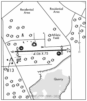
RWY 09–27: H4106X75 (ASPH) S–22 MIRL
RWY 09: REIL. PAPI(P4L)—GA 3.0° TCH 38′. Thld dsplcd 220′. Fence.
RWY 27: REIL. PAPI(P4L)—GA 3.0° TCH 36′. Thld dsplcd 379′. Sign.
SERVICE: FUEL 100LL LGT ACTIVATE REIL Rwy 09 and Rwy 27; PAPI Rwy 09 and Rwy 27; MIRL Rwy 09–27—CTAF. Rwy 09 PAPI unusable 9° left or right of cntrln.
AIRPORTREMARKS: Unattended. Co Road Comsnrs ofc lctd acrs hwy atndd Mon–Fri 1300–2200Z‡. Deer and lrg birds on and invof arpt. Fuel avbl O/R call amgr. Call amgr to vfy snow removal and winter conds. Terminal bldg access, press 5–3–2–1.
AIRPORT MANAGER: 906-430-7718
WEATHER DATA SOURCES: AWOS–3 118.125 (989) 734–7419.
COMMUNICATIONS: CTAF 122.9
ALPENA RCO 122.1R 108.8T (LANSING RADIO)
®ALPENA APP/DEP CON 128.425 (1300–2100Z‡)
®MINNEAPOLIS CENTER APP/DEP CON 125.475 (2100–1300Z‡)
CLEARANCE DELIVERY PHONE: For CD ctc Minneapolis ARTCC at 651-463-5588.
RADIO AIDS TO NAVIGATION: NOTAM FILE APN.
ALPENA (L) (L) VORTAC 108.8 APN Chan 25 N45°04.97′ W83°33.42′ 338° 22.3 NM to fld. 678/7W.
TACAN AZIMUTH unusable:
260°–280° byd 30 NM blo 4,000′
DME portion unusable:
260°–280° byd 30 NM blo 4,000′