PLYMOUTH MUNI (PYM)(KPYM) 4 SW UTC–5(–4DT) N41°54.53′ W70°43.66′
148 B NOTAM FILE PYM
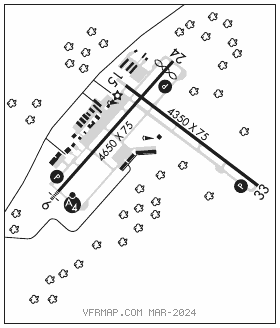
RWY 06–24: H4650X75 (ASPH) S–25, D–64 MIRL
RWY 06: MALSF. PAPI(P4L)–GA 3.0° TCH 40′. Trees.
RWY 24: REIL. PAPI(P4L)–GA 4.0° TCH 40′. Thld dsplcd 300′. Trees.
RWY 15–33: H4350X75 (ASPH) S–25, D–64 MIRL 0.3% up NW
RWY 15: Trees.
RWY 33: PAPI(P4L)–GA 3.0° TCH 40′. Tree.
RUNWAY DECLARED DISTANCE INFORMATION
RWY 15: TORA–4350 TODA–4350 ASDA–4350 LDA–4350
RWY 33: TORA–4350 TODA–4350 ASDA–4650 LDA–4350
SERVICE: S4 FUEL 100LL, JET A OX 2, 4 LGT ACTVT MALSF Rwy 06; REIL Rwy 24; PAPI Rwy 06, 24 and 33; MIRL Rwy 06–24 and 15–33–122.9.
NOISE: Departing acft encouraged to fly local noise abatement procedures.
AIRPORTREMARKS:Attended 1100–0300Z‡. Wildlife on and invof arpt. Be aware of hi–speed military jet and heavy helicopter tfc invof Cape Cod CGAS. No touch and go ldg 0200–1300Z‡.
AIRPORT MANAGER: 508-746-2020
WEATHER DATA SOURCES: ASOS 135.625 (508) 732–8358.
COMMUNICATIONS: CTAF/UNICOM 122.725
®BOSTON CONSOLIDATED TRACON APP/DEP CON 118.2 (1000–0500Z‡)
®BOSTON CENTER APP/DEP CON 128.75 (0500–1000Z‡)
CLNC DEL 127.75
CLEARANCEDELIVERYPHONE:For CD ctc Boston Apch at 603-594-5554. When Apch clsd ctc Boston ARTCC at 603-879-6859.
RADIO AIDS TO NAVIGATION: NOTAM FILE BDR.
MARCONI (VH) (DH) VORW/DME 114.7 LFV Chan 94 N42°01.03′ W70°02.23′ 274° 31.6 NM to fld. 151/16W.
VOR unusable:
245°–250° byd 40 NM
ILS/DME 109.35 I–PYM Chan 30(Y) Rwy 06. Class IT.