PROVIDENCE
RHODE ISLAND TF GREEN INTL (PVD)(KPVD) 6 S UTC–5(–4DT) N41°43.34′ W71°25.66′ 54 B LRA Class I, ARFF Index C NOTAM FILE PVD
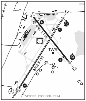
RWY 05–23: H8700X150 (ASPH–GRVD) S–120, D–250, 2S–175, 2D–550, 2D/2D2–1120 PCN 75 F/A/W/T HIRL CL
RWY 05: ALSF2. TDZL. PAPI(P4R)–GA 3.0° TCH 69′. RVR–TMR Trees.
RWY 23: MALSR. VASI(V4L)–GA 3.0° TCH 41′. RVR–TMR Trees.
RWY 16–34: H6081X150 (ASPH–GRVD) S–120, D–250, 2S–175, 2D–423, 2D/2D2–1093 PCN 75 F/A/W/T HIRL 0.3% up N
RWY 16: REIL. PAPI(P4L)–GA 3.0° TCH 49′. RVR–R Thld dsplcd 565′. Pole.
RWY 34: MALSR. PAPI(P4L)–GA 3.0° TCH 60′. RVR–T Trees.
RUNWAY DECLARED DISTANCE INFORMATION
RWY 05: TORA–8700 TODA–8700 ASDA–8700 LDA–8700
RWY 16: TORA–6081 TODA–6081 ASDA–6081 LDA–5516
RWY 23: TORA–8700 TODA–8700 ASDA–8700 LDA–8700
RWY 34: TORA–6081 TODA–6081 ASDA–6081 LDA–6081
ARRESTING GEAR/SYSTEM
RWY 05: EMAS
RWY 16: EMAS
RWY 34: EMAS
SERVICE: S4 FUEL 100LL, JET A LGT When ATCT clsd, ALSF–2 bcms SSALS preset med intst only. When ATCT clsd, ACTVT MALSR Rwy 23 and 34; REIL Rwy 16; PAPI Rwy 05, 16 and 34; VASI Rwy 23; TDZ Rwy 05; cntln Rwy 05–23; HIRL Rwy 05–23 and 16–34–CTAF.
NOISE: Noise abatement procs in efct. Hels avoid resl areas when blw 1000′.
AIRPORT REMARKS: Attended continuously. Deer and birds on and invof arpt. 110′ unmarked lgt poles 2700′ from thld Rwy 34; 900′ left of cntrln. ASDE–X in use. Operate transponders with altitude reporting mode and ADS–B (if equipped) enabled on all airport surfaces. Terminal ramp prohibited for use to general aviation. Parked acft on the northeast ramp west of Twy A, be alert. Freq flt school, tran jet acft, and vertical activity. Northwest ramp acft with wingspan greater than 110′ req gnd crew assistance for thru taxi and parking. Northeast ramp acft with wingspan greater than 150′ req ground crew assistance for thru taxi and parking. Run up pad for Twy F clsd to acft with wingspan over 118′. Twy V clsd daily 0100–1300Z‡, btn Rwy 16–34 and Twy C. Gnd vehicles monitor CTAF when twr clsd. Ldg fee. Flight Notification Service (ADCUS) available.
AIRPORT MANAGER: 401-691-2000
WEATHER DATA SOURCES: ASOS 124.2 (401) 734–2818. LLWAS.
COMMUNICATIONS: CTAF 120.7 D–ATIS 124.2 (401) 737–3215
PROVIDENCE RCO 122.6 (BRIDGEPORT RADIO)
®PROVIDENCE APP/DEP CON 123.675 (Sun–Fri 1030–0530Z‡, Sat 1030–0500Z‡) other times ctc
BOSTON CENTER APP/DEP CON 124.85
PROVIDENCE TOWER 120.7 (Sun–Fri 1030–0530Z‡, Sat 1030–0500Z‡) GND CON 121.9 CLNC DEL 126.65
BRIDGEPORT RADIO CLNC DEL 122.6 (0500–1100Z‡)
PDC
CLEARANCE DELIVERY PHONE: For CD when Apch clsd ctc Boston ARTCC at 603-879-6859.
AIRSPACE: CLASS C svc ctc APP CON svc Sun–Fri 1030–0530Z‡, Sat 1030–0500Z‡; other times CLASS E.
VOR TEST FACILITY (VOT) 108.2
RADIO AIDS TO NAVIGATION: NOTAM FILE PVD.
PROVIDENCE (H) (DH) VORW/DME 115.6 PVD Chan 103 N41°43.46′ W71°25.78′ at fld. 49/14W.
VOR unusable:
085°–105° byd 12 NM blo 5,500′
085°–105° byd 8 NM blo 3,000′
106°–294° byd 30 NM blo 3,000′
295°–330° byd 30 NM blo 6,000′
331°–084° byd 30 NM blo 3,000′
DME unusable:
085°–105° byd 12 NM blo 5,500′
085°–105° byd 8 NM blo 3,000′
106°–152° byd 11 NM blo 2,000′
106°–152° byd 20 NM blo 4,000′
153°–294° byd 30 NM blo 3,000′
295°–330° byd 30 NM blo 6,000′
331°–084° byd 30 NM blo 3,000′
ILS/DME 109.3 I–PVD Chan 30 Rwy 05. Class IIIE. Cat II and Cat III unavbl when ATCT closed.
ILS/DME 109.3 I–ARJ Chan 30 Rwy 23. Class IIE. DME unusable byd 10 NM blw 1,900′.
ILS/DME 111.5 I–UNQ Chan 52 Rwy 34. Class IE. Glideslope unusable byd 4° right of course. Glideslope autopilot cpd apch NA blw 300′.