PROVINCETOWN MUNI (PVC)(KPVC) 2 NW UTC–5(–4DT) N42°04.34′ W70°13.24′
8 B NOTAM FILE PVC
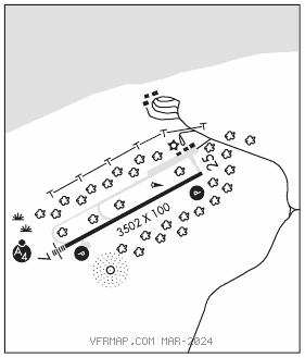
RWY 07–25: H3502X100 (ASPH) S–25 HIRL
RWY 07: MALSF. PAPI(P4R)–GA 3.0° TCH 40′.
RWY 25: REIL. PAPI(P4L)–GA 3.0° TCH 40′. Trees. Rgt tfc.
SERVICE: FUEL 100LL LGT Actvt MALSF Rwy 07; REIL Rwy 25; PAPI Rwy 07 & 25; HIRL Rwy 07–25–122.85.
AIRPORT REMARKS: Attended May–Oct, dalgt hrs, Nov–Apr, Mon–Sat 1100–2300Z‡, Sun 1100–2200Z‡. For 100LL fuel avblty–Amgr. Wildlife on and invof arpt. High spd mil and hel tfc invof Cape Cod CGAS. Ultralight ops na May 1–Sep 30. Prkg fee. Lndg fee arpt.
AIRPORT MANAGER: 508-487-0241
WEATHER DATA SOURCES: AWOS–3PT 119.275 (508) 487–6435.
COMMUNICATIONS: CTAF/UNICOM 122.8
®BOSTON CONSOLIDATED TRACON APP/DEP CON 118.2 (1000–0500Z‡)
®BOSTON CENTER APP/DEP CON 128.75 (0500–1000Z‡)
CLNC DEL 120.65
CLEARANCE DELIVERY PHONE: For CD ctc Boston Apch at 603-594-5554. When Apch clsd ctc Boston ARTCC at 603-879-6859.
RADIO AIDS TO NAVIGATION: NOTAM FILE BDR.
MARCONI (VH) (DH) VORW/DME 114.7 LFV Chan 94 N42°01.03′ W70°02.23′ 308° 8.8 NM to fld. 151/16W.
VOR unusable:
245°–250° byd 40 NM
NDB (MHW) 389 PVC N42°04.13′ W70°13.41′ at fld. 9/16W. NOTAM FILE PVC.
ILS/DME 111.1 I–VQO Chan 48 Rwy 07. Class IB. Unmonitored.