PALESTINE MUNI (PSN)(KPSN) 4 NW UTC–6(–5DT) N31°46.78′ W95°42.38′
423 B NOTAM FILE PSN
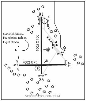
RWY 18–36: H5005X100 (ASPH) S–45, D–70, 2D–135 MIRL
RWY 18: PAPI(P4L)—GA 3.0° TCH 45′. Tree.
RWY 36: REIL. PAPI(P4L)—GA 3.0° TCH 35′. Trees.
RWY 09–27: H4002X75 (ASPH) S–45, D–70, 2D–135 MIRL 0.9% up W
RWY 09: Trees.
RWY 27: Trees.
SERVICE: FUEL 100LL, JET A LGT MIRL Rwy 18–36 preset low intst dusk–dawn; to incr intst ACTVT—CTAF. Rwy 36 REIL OTS indefly.
AIRPORT REMARKS: Attended Mon–Sat 1400–2300Z‡. For svc aft hrs call 903–724–2225. Rwy 09–27 clsd daily SS–SR, perm.
AIRPORT MANAGER: 903-723-0111
WEATHER DATA SOURCES: AWOS–3PT 118.025 (903) 729–3641.
COMMUNICATIONS: CTAF/UNICOM 122.7
®FORT WORTH CENTER APP/DEP CON 135.25
CLEARANCE DELIVERY PHONE: For CD ctc Fort Worth ARTCC at 817-858-7584.
RADIO AIDS TO NAVIGATION: NOTAM FILE FTW.
FRANKSTON (L) (L) VORW/DME 111.4 FZT Chan 51 N32°04.48′ W95°31.85′ 201° 19.8 NM to fld. 305/6E.
VOR portion unusable:
270°–293° byd 5 NM blo 8,000′
293°–295° byd 25 NM blo 3,500′
295°–340° byd 20 NM