PONCA CITY RGNL (PNC)(KPNC) 2 NW UTC–6(–5DT) N36°43.92′ W97°05.99′
1009 B NOTAM FILE PNC MON Airport
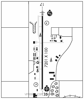
RWY 17–35: H7201X100 (CONC–GRVD) S–51, D–65, 2S–83, 2D–122 HIRL
RWY 17: MALSR. PAPI(P4L)—GA 3.0° TCH 52′. Rgt tfc.
RWY 35: ODALS. PAPI(P4L)—GA 3.0° TCH 46′. Bldg.
SERVICE: S4 FUEL 100LL, JET A OX 4 LGT Actvt MALSR Rwy 17; ODALS Rwy 35; HIRL Rwy 17–35—CTAF. PAPI Rwy 17 and 35 on consly. Rwy 35 PAPI unusbl byd 8 degs right of cntrln. FUEL 100LL avbl 24 hr.; Jet A and svc avbl 1300Z‡–dusk; otr times 580–767–0429.
AIRPORT REMARKS: Attended 1300–0100Z‡. Ultralights on and invof arpt. Rwy 17–35 north 2400′ nstd plastic grooving entire width; 25′ each edge at remaining of 4801′.
AIRPORT MANAGER: 580-767-0470
WEATHER DATA SOURCES: ASOS 134.075 (580) 765–0049.
COMMUNICATIONS: CTAF/UNICOM 123.0
RCO 122.2 (MC ALESTER RADIO)
®KANSAS CITY CENTER APP/DEP CON 127.8
CLEARANCEDELIVERYPHONE:For CD if una to ctc on FSS freq, ctc Kansas City ARTCC at 913-254-8508.
AIRSPACE: CLASS E.
RADIO AIDS TO NAVIGATION: NOTAM FILE PNC.
PIONEER (VH) (H) VORTACW 113.2 PER Chan 79 N36°44.79′ W97°09.61′ 101° 3.0 NM to fld. 1054/6E.
TACAN AZIMUTH unusable:
184°–194° byd 15 NM blo 3,000′
NDB (MHW/LOM) 515 PN N36°49.50′ W97°06.03′ 175° 5.6 NM to fld. 1038/5E.
ILS/DME 111.9 I–PNC Chan 56 Rwy 17. LOM PONCA NDB. Unmonitored.