PALMDALE USAF PLANT 42 (PMD)(KPMD) MIL/CIV AF 3 NE UTC–8(–7DT) N34°37.76′
W118°05.07′ 2543 B TPA–See Remarks NOTAM FILE PMD
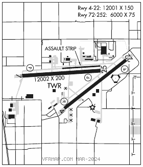
RWY 07–25: H12002X200 (CONC) PCN 71 R/B/W/T HIRL
RWY 07: REIL. PAPI(P4L)–GA 3.0° TCH 78′. 0.5% down.
RWY 25: REIL. PAPI(P4L)–GA 3.0° TCH 76′. Rgt tfc.
RWY 04–22: H12001X150 (CONC) PCN 53 R/B/W/T HIRL
RWY 04: REIL. PAPI(P4L)–GA 3.0° TCH 75′. Hill. Rgt tfc. 0.6% down.
RWY 22: REIL. PAPI(P4L)–GA 3.0° TCH 75′. 0.3% up.
RWY 072–252: H6000X75 (CONC) PCN 97 R/B/W/T
SERVICE: LGT ACTVT REIL Rwy 04, 07, 22, 25; HIRL Rwy 04–22 and Rwy 07–25–CTAF. PAPI Rwy 04, 07, 22and Rwy 25 on consly. Rwy 07 VGSI unusbl byd 5.0 NM due to terrain. Rwy 04 VGSI unusbl byd 5.0 NM. MILITARY– JASU Pwr carts unavbl. FUEL A++. Ltd fueling avbl; govt acft only 1600–2300Z‡ Mon–Fri. 24 hr PN with Afld Mgt rqr; no same day req; Gas and go unavbl. Expect 2+ hr delay for fuel.
TRAN ALERT No fleet svc avbl. No Flw Me svc avbl. Exp progressive taxi to prk. Aircrew responsible for acft pinning/safing. Unable to svc acft with ordnance. Ltd gnd support eqpt avbl. No potable water svc. No tran maint avbl. Gnd svc unavbl when lightning within 5 NM.
AIRPORT REMARKS: Attended 1330–0600Z‡ other times CLOSED to all tfc without written approval. PPR for all full stop ldg only. Call 661–272–6619/6614 during duty hrs, 661–272–6600 after duty hrs. Bird hazard. Drainage ditches parallel Rwy 22 from Twy S to Twy U. Primarily training 747–707–727. All department acft must file fpl with P42 afld mgmt ops. Unlighted obstructions surround airfield. Rwy 07, Rwy 04 and Rwy 22 3′ wooden box at 150′ from thld. Parking ramp located south of Rwy 22 and Twy V not visible from twr. Assault ldg zone lctd 1st 6,000 east end of Twy B. Rwy 252 mark only for C–130 assault opr, one way ldg only. Ldg fee.
MILITARY REMARKS: Official business only, Military arpt civil use requires USAF approval and DD form 240001/02. See FLIP AP/1 Supplementary Arpt Remarks. RSTD Offl bus only. Mil arpt. Civil use rqr USAF apvl and DD Form 240001/02. PPR rqr for full stop ldg only. Call C661–275–9342. Rwy 072–252 used as a military assault strip. Assault ldg zone located 1st 6000′ east end of Twy B. Rwy 252 mark only for C–130 assault opr, one –way ldg only. Assault Landing Zone one way landing assault landing zone 25 only. Rwy 252 mark only for C–130 assault opr, one–way ldg only. Use of assault strip ldg zone req prior coordination with 146 OSF/OSK DSN 893–7590, C805–986–7590. Overnight park unauthorized on C ramp. Twy L between Rwy 04–22 and passenger terminal unlighted and usable for daylight VFR only. CAUTION Contractor leased sites are intended for acft based therein, entry gates and aprons may not meet Air Force obst stds. Rwy 07–25 1000′ asph overrun each end, overrun poor condition emergency use only. Rwy 04–22 1150′ asph overrun each end, overrun poor condition, emergency use only. Use extreme caution for unmanned aerial systems (UAS) ops in vicinity. Civ acft may not be granted access to KPMD Class D for practice apch or trsn over aprt bdrys. Last 7000′ of Rwy 25, south side, 300′ from rwy centerline, ground sfc has terrain irregularities and violates graded area required. Various acft test ops makings painted in white on twy uniform. Rwy 25 NSTD marking. Spot ldg zone mark located at 6000′ remaining mark. Rwy 07–25 deceptive sfc mark exceed standard by approximately 50′. TFC PAT TPA overhead 4500(1957). Rectangular 4000(1457). Exp right tfc Rwy 04, Rwy 25. MISC Base ops opr 1330–0600Z‡, clsd federal hol. Winds are estimated due to FMQ–13 wind sensors being accurate to within only +/– 2 Kt. ATC/Wx will not include/relay wind correction into forecasts/phraseology. Therefore, aircrews will incorporate a +/– 2 Kt accuracy into their decision making process for flying opr. Flight plans must be filed and activated with P42 afld management. Use flt svc when P42 afld management clsd. No transportation, lodging or nml svc avbl on site. COMSEC storage unavbl.
AIRPORT MANAGER: 661-275-9342
WEATHER DATA SOURCES: ASOS (661) 272–3798
COMMUNICATIONS: CTAF 123.7 ATIS 118.275
JOSHUA APP/DEP CON 124.55 363.0
TOWER 123.7 317.6 (1330–0600Z‡, other times clsd to all tfc without written approval, due to mil ops during twr clsd)
GND CON 121.9 317.6
AIRSPACE: CLASS D svc 1330–0600Z‡; other times CLASS G.
RADIO AIDS TO NAVIGATION: NOTAM FILE PMD.
(H) (H) VORTACW 115.55 PMD Chan 102(Y) N34°37.88′ W118°03.83′ 248° 1.0 NM to fld. 2498/15E.
VOR unusable:
120°–183° byd 25 NM blo 13,500′
120°–183° byd 35 NM
184°–207° byd 16 NM blo 13,000′
184°–207° byd 25 NM
219°–227° byd 17 NM blo 9,000′
219°–227° byd 24 NM
228°–239° byd 22 NM blo 9,000′
228°–239° byd 24 NM
TACAN AZIMUTH unusable:
120°–183° byd 25 NM blo 13,500′
120°–183° byd 35 NM
184°–207° byd 16 NM blo 13,000′
184°–207° byd 25 NM
219°–227° byd 17 NM blo 9,000′
219°–227° byd 24 NM
228°–239° byd 22 NM blo 9,000′
228°–239° byd 24 NM
DME unusable:
120°–183° byd 25 NM blo 13,500′
120°–183° byd 35 NM
184°–207° byd 16 NM blo 13,000′
184°–207° byd 25 NM
219°–227° byd 17 NM blo 9,000′
219°–227° byd 24 NM
228°–239° byd 22 NM blo 9,000′
228°–239° byd 24 NM
ILS 110.7 I–PMD Rwy 25. Class ID. Unmonitored when ATCT clsd.