OTTAWA MUNI (OWI)(KOWI) 4 S UTC–6(–5DT) N38°32.35′ W95°15.19′
966 B NOTAM FILE ICT
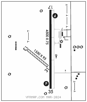
RWY 17–35: H4500X75 (CONC) S–30, D–30 PCN 11 R/C/X/U MIRL
RWY 17: REIL. PAPI(P2L)–GA 3.25° TCH 26′. Tree. Rgt tfc.
RWY 35: REIL. PAPI(P2L)–GA 3.25° TCH 28′.
RWY 13–31: 1550X95 (TURF) 0.4% up NW
RWY 13: Tree. Rgt tfc.
RWY 31: Pole.
SERVICE: FUEL 100LL, JET A LGT ACTIVATE REIL Rwys 17 and Rwy 35; PAPI Rwy 17 and Rwy 35–CTAF. MIRL Rwy 17–35 preset on low ints, to incr ints–CTAF.
AIRPORTREMARKS:Attended Tue–Sat 1400–2000Z‡. FBO SVCS not AVBL Easter, Thanksgiving and Christmas day. Wildlife on and invof arpt. Ultralight activity on and invof arpt. +75′ poles 1700′ north of AER 17 mkd with red lights. P–line mkd with red balls. Rwy 13–31 mkd or delineated with white buckets.
AIRPORT MANAGER: 785-242-5310
WEATHER DATA SOURCES: AWOS–3PT 118.25 (785) 242–2185.
COMMUNICATIONS: CTAF/UNICOM 122.8
®KANSAS CITY CENTER APP/DEP CON 127.725
CLEARANCE DELIVERY PHONE: For CD ctc Kansas City ARTCC at 913-254-8508.
RADIO AIDS TO NAVIGATION: NOTAM FILE TOP.
TOPEKA (VL) (L) VORTACW 117.8 TOP Chan 125 N39°08.22′ W95°32.95′ 154° 38.4 NM to fld. 1075/5E.