OROVILLE MUNI (OVE)(KOVE) 3 SW UTC–8(–7DT) N39°29.27′ W121°37.32′
194 B TPA–994(800) NOTAM FILE OVE
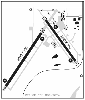
RWY 02–20: H6020X100 (ASPH) S–47, D–90 HIRL
RWY 02: REIL. PAPI(P2L)–GA 3.0° TCH 44′.
RWY 20: REIL. PAPI(P2L)–GA 3.0° TCH 40′.
RWY 13–31: H3540X100 (ASPH) S–19, D–31 HIRL 0.4% up NW
RWY 13: PAPI(P2L)–GA 3.0° TCH 39′.
RWY 31: PAPI(P2L)–GA 3.0° TCH 29′. Trees.
SERVICE: S3 FUEL 100LL, JET A LGT ACTVT REIL Rwy 02 and 20; PAPI Rwy 02, 13, 20 and 31; HIRL Rwy 02–20 and Rwy 13–31–CTAF. VGSI Rwy 20 does not provide obstruction clearance byd 3 NM.
AIRPORT REMARKS: Attended Mon–Sat 1600–0100Z‡. For Arpt information Mon–Fri ctc (530) 538–2490. Firefighting acft invof arpt May–Oct. Twy from Rwy 02–20 to golf course/restaurant tiedowns 20′ wide with no shoulders.
AIRPORT MANAGER: 530-538-2490
WEATHER DATA SOURCES: ASOS 121.425 (530) 533–5792.
COMMUNICATIONS: CTAF/UNICOM 122.8
®NORCAL APP/DEP CON 125.4
CLEARANCE DELIVERY PHONE: For CD ctc NorCal Apch at 916-361-6874.
RADIO AIDS TO NAVIGATION: NOTAM FILE MYV.
MARYSVILLE (T) (T) VOR/DME 110.8 MYV Chan 45 N39°05.92′ W121°34.38′ 338° 23.4 NM to fld. 62/16E.