WORCESTER RGNL (ORH)(KORH) 3 W UTC–5(–4DT) N42°16.03′ W71°52.54′
1009 B LRA Class I, ARFF Index B NOTAM FILE ORH
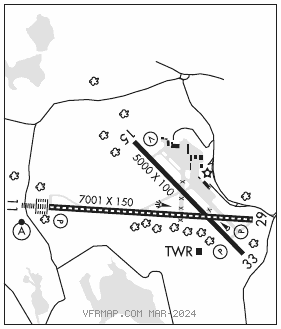
RWY 11–29: H7001X150 (ASPH–GRVD) S–120, D–250, 2S–138, 2D–550 PCN 89 F/C/W/T HIRL CL
RWY 11: ALSF2. TDZL. PAPI(P4R)–GA 3.0° TCH 55′. RVR–TR Hill.
RWY 29: REIL. PAPI(P4L)–GA 3.0° TCH 54′. RVR–TR
RWY 15–33: H5000X100 (ASPH–GRVD) S–85, D–120, 2S–138, 2D–210 PCN 35 F/C/W/T MIRL
RWY 15: REIL. VASI(V4L)–GA 3.6° TCH 42′. Antenna.
RWY 33: REIL. PAPI(P4L)–GA 3.0° TCH 40′.
RUNWAY DECLARED DISTANCE INFORMATION
RWY 11: TORA–7001 TODA–7001 ASDA–7001 LDA–7001
RWY 15: TORA–5000 TODA–5000 ASDA–5000 LDA–5000
RWY 29: TORA–7001 TODA–7001 ASDA–7001 LDA–7001
RWY 33: TORA–5000 TODA–5000 ASDA–5000 LDA–5000
ARRESTING GEAR/SYSTEM
RWY 11: EMAS
RWY 29: EMAS
SERVICE: S4 FUEL 100LL, JET A LGT Actvt REIL Rwy 15, 29 and 33; HIRL Rwy 11–29; MIRL Rwy 15–33–CTAF. Rwy 11 ALSF–2 becomes SSALS preset on med intst only when twr clsd. Rwy 15 VASI unubl byd 9° left of crs.
AIRPORT REMARKS: Attended continuously. Wildlife and birds on and invof arpt. Use ctn for arpt vehicles mnt CTAF and operg on arpt durg non twr hrs. Rwy guard lgts installed on all twy to rwy intersections, Rwy 11–29 only. EMAS 170′ wide, 154′ length located at DER 11. EMAS 170′ wide, 300′ length located at DER 29. Ldg fee for multi–eng acft and lrgr. Flight Notification Service (ADCUS) available. 2 hours advance notice for customs.
AIRPORT MANAGER: 508-849-5550
WEATHER DATA SOURCES: ASOS (508) 795–7546
COMMUNICATIONS: CTAF 120.5 ATIS 126.55 (508) 757–0962 UNICOM 122.95
RCO 122.2 (BRIDGEPORT RADIO)
®BRADLEY APP/DEP CON 119.0 CLNC DEL 119.0 (0200–1130Z‡)
TOWER 120.5 (1130–0200Z‡) GND CON 123.85 CLNC DEL 128.65
AIRSPACE: CLASS D svc 1130–0200Z‡; other times CLASS E.
VOR TEST FACILITY (VOT) 108.2
RADIO AIDS TO NAVIGATION: NOTAM FILE BDR.
GARDNER (L) (L) VOR/DME 116.95 GDM Chan 116(Y) N42°32.76′ W72°03.49′ 168° 18.6 NM to fld. 128014W.
ILS/DME 110.9 I–RSR Chan 46 Rwy 11. Class III/E. Unmonitored when ATCT closed. DME unusable byd 12° left of course; byd 13 NM; byd 25° right of course.
ILS/DME 110.9 I–EKW Chan 46 Rwy 29. Class IB. Unmonitored when ATCT clsd. Glideslope unusable for coupled apchs blo 1,266′ MSL. LOC unusable byd 25° left and byd 25° right of course.
COMM/NAV/WEATHER REMARKS: Durg sn removal ops, 30 min PPR, freq 120.50 durg twr hrs, freq 119.0 durg non twr hrs or call 508–799–1325. Tsnt acft ctc FBO on 122.95 for svcs.