ORANGE CO (ORG)(KORG) 3 SW UTC–6(–5DT) N30°04.11′ W93°48.24′
13 B NOTAM FILE ORG
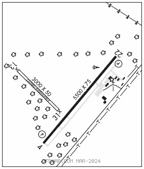
RWY 04–22: H5500X75 (ASPH) S–27 MIRL
RWY 04: REIL. PAPI(P2L)—GA 3.0° TCH 22′. Trees.
RWY 22: REIL. PAPI(P2L)—GA 3.0° TCH 21′. Trees.
RWY 13–31: 3000X50 (TURF)
RWY 13: Tree.
RWY 31: Trees.
SERVICE: S4 FUEL 100LL, JET A LGT MIRL Rwy 04–22 preset low intst; to incr intst and ACTVT REIL Rwy 04 and 22—CTAF.
AIRPORTREMARKS:Attended 1300–2300Z‡. Rwy 13–31 CLOSED indefly. Rwy 13–31 rwy not mntnd, rwy sfc rough, deep ruts, not suitable for acft. Trees obstruct primary sfc Rwy 13–31. 3 ft open drainage culvert at thr, 31 ft both sides.
AIRPORT MANAGER: (409) 882-7861
WEATHER DATA SOURCES: AWOS–3 118.975 (409) 670–9591.
COMMUNICATIONS: CTAF/UNICOM 122.8
®HOUSTON APP/DEP CON 121.3
CLEARANCEDELIVERYPHONE:For CD ctc Houston Apch at 281-443-5844 to cnl IFR call 281-443-5888.
RADIO AIDS TO NAVIGATION: NOTAM FILE BPT.
BEAUMONT (L) DME 114.5 BPT Chan 92 N29°56.76′ W94°00.97′ 056° 13.3 NM to fld. 7.