ONTARIO INTL (ONT)(KONT) P (ANG) 2 E UTC–8(–7DT) N34°03.36′ W117°36.07′
944 B Class I, ARFF Index D NOTAM FILE ONT MON Airport
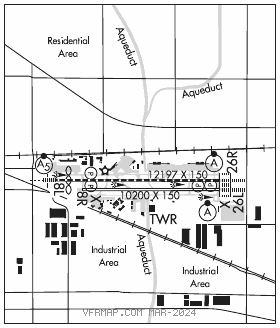
RWY 08L–26R: H12197X150 (CONC–GRVD) S–30, D–200, 2S–175, 2D–560, 2D/2D2–850 PCN 102R/B/W/T HIRL CL
RWY 08L: MALSR. TDZL. PAPI(P4L)–GA 3.0° TCH 62′. RVR–TMR Thld dsplcd 997′. Railroad.
RWY 26R: ALSF2. TDZL. PAPI(P4L)–GA 3.0° TCH 75′. RVR–TMR Pole. Rgt tfc.
RWY 08R–26L: H10200X150 (CONC–GRVD) S–30, D–200, 2S–175, 2D–560, 2D/2D2–850 PCN 70 R/B/W/T HIRL CL
RWY 08R: PAPI(P4L)–GA 3.0° TCH 65′. RVR–TMR Rgt tfc.
RWY 26L: ALSF2. TDZL. PAPI(P4R)–GA 3.0° TCH 74′. RVR–TMR Pole.
RUNWAY DECLARED DISTANCE INFORMATION
RWY 08L:TORA–12197 TODA–12197 ASDA–12197 LDA–11200
RWY 08R:TORA–10200TODA–10200 ASDA–10200 LDA–10200
RWY 26L:TORA–10200 TODA–10200 ASDA–10200 LDA–10200
RWY 26R:TORA–12197TODA–12197 ASDA–12197 LDA–12197
SERVICE: S4 FUEL 100LL, JET A, J OX 3, 4 MILITARY– FUEL A+, A (1400–0600Z‡, C909–635–4728.) (NC–100LL)FLUID OX TRAN ALERT All mil and civ general avn acft ops rstd to FBO fac. PPR. Overngt tie–down and prk fee.
NOISE: Noise abatement procedures in effect; full–length turbojet departures encouraged, nightly preferential rwy usage, 0600–1500Z‡.
AIRPORTREMARKS:Attended continuously. Wildlife hazard management plan in effect; potential bird hazards may exist on and invof arpt; be alert to large numbers of starlings and crows possible on approach to Rwy 26L and Rwy 26R, hawks, eagles, falcons and owls spotted on occasion. Acft prkg and contr gnd svc are ltd for unsked ops. For sked info call afld ops (909) 214–7682/7683. Pilots should use judgmental oversteer on Twy S–4. Twy Y east of Twy W is a non–movement area; all acft ctc ramp ctl 131.325 for access. Twy S–4 rstd to acft with wingspan 117′ or smaller. Acft access to Twy R from Rwy 26R prohibited. Eastbound B747, B777, A330, A340 or larger acft on Twy S prohibited from northbound turns onto Twy K. B747, B777, A330, A340 or larger acft on Twy S prohibited from northbound turns onto Twy P. Twy F south of Twy S rstd to acft with 117′ wingspan and smaller. Twy F south of Rwy 26L rstd to acft with 180′ wingspan. Portions of Twy S in the vicinity of Twy F are not visible from twr, pilots use caution entering Twy F south of Twy S. Runway visibility value Rwy 08L and Rwy 26R avbl. Runway visibility value Rwy 08R and Rwy 26L avbl. All military and general aviation (fixed or rotor wing) acft opr are rstd to FBO facilities with advance coordination overnight tiedown and parking fee. FBO on frequency 130.75. User fee arpt.
AIRPORT MANAGER: 909-544-5300
WEATHER DATA SOURCES: ASOS (909) 937–2186 LAWRS. WSP.
COMMUNICATIONS: D–ATIS 124.25 909–605–0056
®SOCAL APP/DEP CON 127.0 (North–NE) 134.0 (NE–South) 135.4 (South–SW)
TOWER 120.6 GND CON 121.9 CLNC DEL 132.9
CPDLC (LOGON KUSA)
PDC
AIRSPACE: CLASS C svc ctc APP CON.
RADIO AIDS TO NAVIGATION: NOTAM FILE RAL.
POMONA (L) (L) VORTACW 110.4 POM Chan 41 N34°04.70′ W117°47.22′ 083° 9.4 NM to fld. 1265/15E.
DME unusable:
300°–045° byd 20 NM
VOR unusable:
280°–300° byd 20 NM blo 13,000′
300°–045° byd 20 NM
TACAN AZIMUTH unusable:
280°–300° byd 20 NM blo 14,000′
300°–045° byd 20 NM
PETIS NDB (HW) 397 SB N34°03.39′ W117°21.97′ 256° 11.7 NM to fld. 972/14E. NOTAM FILE ONT.
ILS 109.7 I–AOD Rwy 08L. Class IE.
ILS/DME 111.35 I–TWO Chan 50(Y) Rwy 26L. Class IIIE.
ILS/DME 109.7 I–ONT Chan 34 Rwy 26R. Class IE.