OCEANSIDE
BOB MAXWELL MEML AIRFIELD (OKB)(KOKB) 2 NE UTC–8(–7DT) N33°13.08′ W117°21.09′ 28 B NOTAM FILE OKB
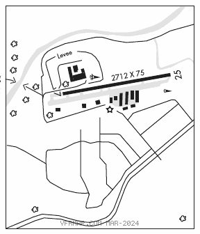
RWY 07–25: H2712X75 (ASPH) S–12 MIRL
RWY 07: Road.
RWY 25: REIL. Hill. Rgt tfc.
SERVICE: S6 FUEL 100LL, JET A LGT Arpt bcn SS–SR. MIRL Rwy 07–25 preset low ints, to incr ints ACTVT–CTAF.
NOISE: Noise abatement in efct: Flw riverbed all the way to coast prior to making any turns. Do not fly over any houses alg river banks. No early turnouts prior to the ocean. Skydiving ops in efct SR–SS daily. Prcht lndg north side of rwy btw downwind and rwy, no efct on acft tkof/lndg that flw tfc pat. Use ctn while in the pat.
AIRPORT REMARKS: Attended 1700–0100Z‡. Fuel avbl 24 hrs 100LL self svc, full svc 1700–0030Z‡; Jet A 1700–0100Z‡. Parachute jumping. Birds on and invof arpt. Rwy has no pavement marking or edge lights byd dsplcd thld. All tfc patterns to north. Mts W, NW, SW Rwy 07 up to 280 ft MSL. Unlgtd mt aprx 160 ft MSL in apch zone at 3500 ft from W end of pvmt Rwy 07. Do not confuse road south of arpt with the rwy. Fence and road within primary surface north side.
AIRPORT MANAGER: (760) 901-4260
WEATHER DATA SOURCES: ASOS 127.8 (760) 439–9683.
COMMUNICATIONS: CTAF/UNICOM 122.725
RCO 122.1R 115.3T (SAN DIEGO RADIO)
®SOCAL APP/DEP CON 127.3
CLEARANCE DELIVERY PHONE: For CD ctc SoCal Apch at 800-448-3724.
RADIO AIDS TO NAVIGATION: NOTAM FILE CRQ.
OCEANSIDE (VH) (H) VORTAC 115.3 OCN Chan 100 N33°14.44′ W117°25.06′ 097° 3.6 NM to fld. 52/15E.
VOR unusable:
028°–036° byd 40 NM
039°–048° byd 40 NM
049°–059° byd 40 NM blo 13,000′
049°–059° byd 58 NM
060°–099° byd 40 NM
100°–114° byd 40 NM blo 7,000′
100°–114° byd 61 NM
216°–226° byd 40 NM
227°–265° byd 20 NM
305°–320° byd 40 NM
330°–335° byd 40 NM
337°–017° byd 40 NM