JOHNSON CO EXEC (OJC)(KOJC) 4 SE UTC–6(–5DT) N38°50.86′ W94°44.26′
1096 B TPA–See Remarks NOTAM FILE OJC
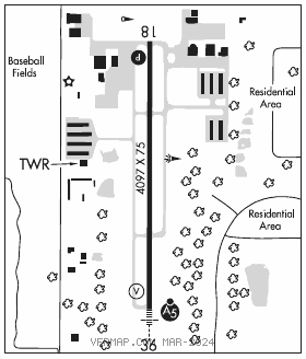
RWY 18–36: H4097X75 (CONC) S–12.5 MIRL 1.1% up N
RWY 18: PAPI(P4R)–GA 3.0° TCH 40′.
RWY 36: MALSR. VASI(V2L)–GA 3.0° TCH 40′. Trees.
SERVICE: S4 FUEL 100LL, JET A OX 2, 4 LGT When twr clsd ACTIVATE MIRL Rwy 18–36, MALSR Rwy 36, twy lgts and wind cone–CTAF. VASI Rwy 18 and Rwy 36 opr continuously.
AIRPORT REMARKS: Attended continuously. To confirm snow removal and winter conditions Nov–Apr call 913–292–9964. Birds, waterfowl, wildlife on and invof arpt. It is advised that rotocraft avoid the overflights of surrounding neighborhoods. Acft exceeding 12,500 lbs must ctc arpt manager at 913–715–6000 for PPR. Upon takeoff for Rwys 18 and 36 maintain rwy heading until passing 1,600′ MSL. TPA–low performance acft 2096 (1000), high performance acft 2596 (1500).
AIRPORT MANAGER: 913-715-6000
WEATHER DATA SOURCES: ASOS (913) 780–6969 LAWRS.
COMMUNICATIONS: CTAF 126.0 ATIS 119.35 913–764–9272
UNICOM 122.95
®KANSAS CITY APP/DEP CON 118.9
EXECUTIVE TOWER 126.0 (1300–0300Z‡) GND CON 121.6
CLEARANCE DELIVERY PHONE: For CD when ATCT is clsd ctc MCI Apch at 816-329-2710.
AIRSPACE: CLASS D svc 1300–0300Z‡; other times CLASS G.
RADIO AIDS TO NAVIGATION: NOTAM FILE MCI.
KANSASCITY (H)(H) VORTACW 113.25 MCI Chan 79(Y) N39°17.12′ W94°44.22′ 175° 26.2 NM to fld. 1017/5E.
HERBB NDB (LOMW) 420 PK N38°45.19′ W94°44.21′ 356° 5.7 NM to fld. 1103/4E. NOTAM FILE OJC.
LOC/DME 111.1 I–OJC Chan 48 Rwy 18. Unmonitored when twr clsd.
LOC 108.3 I–PKX Rwy 36. LOM HERBB NDB. Unmonitored when tower clsd.
COMM/NAV/WEATHER REMARKS: Freq 121.5 not available at tower.
HELIPORT REMARKS: Helipad H1 CLOSED indefinitely.