OAKLAND
METRO OAKLAND INTL (OAK)(KOAK) 4 S UTC–8(–7DT) N37°43.28′ W122°13.27′ 9 B TPA–See Remarks LRA Class I, ARFF Index D NOTAM FILE OAK
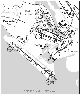
RWY 12–30: H10520X150 (ASPH–GRVD) S–120, D–250, 2D–550, 2D/2D2–1120 PCR 1295 F/B/X/T HIRL CL
RWY 12: MALSR. PAPI(P4R)–GA 2.75° TCH 70′. RVR–TMR Rgt tfc.
RWY30: ALSF2. TDZL. PAPI(P4L)–GA 3.0° TCH 71′. RVR–TMR Thld dsplcd 114′.
RWY 10R–28L: H6213X150 (ASPH–GRVD) S–120, D–250, 2D–550, 2D/2D2–1120 PCR 934 F/B/X/T HIRL
RWY 10R: REIL. PAPI(P4L)–GA 3.0° TCH 50′.
RWY 28L: PAPI(P4R)–GA 3.0° TCH 50′.
RWY 10L–28R: H5457X150 (ASPH–GRVD) S–120, D–250, 2D–550, 2D/2D2–1120 PCR 1266 F/B/X/T HIRL
RWY 10L: PAPI(P4R)–GA 3.0° TCH 50′. RVR–R
RWY28R: MALSR. PAPI(P4L)–GA 3.0° TCH 51′. RVR–T Bldg. Rgt tfc.
RWY 15–33: H3376X75 (ASPH) S–12.5, D–65, 2D–100 MIRL
RWY 33: Rgt tfc.
RUNWAY DECLARED DISTANCE INFORMATION
RWY 10L:TORA–5457 TODA–5457 ASDA–5336 LDA–5336
RWY 10R:TORA–6213 TODA–6213 ASDA–6213 LDA–6213
RWY 12: TORA–10000 TODA–10000 ASDA–10000 LDA–10000
RWY 28L:TORA–6213 TODA–6213 ASDA–6213 LDA–6213
RWY 28R:TORA–5457 TODA–5457 ASDA–5457 LDA–5457
RWY 30: TORA–10000 TODA–10000 ASDA–10000 LDA–10000
ARRESTING GEAR/SYSTEM
RWY 28L: EMAS
SERVICE: S4 FUEL 100LL, JET A OX 1, 2, 3, 4
NOISE: 24 hr Noise abatement procedure–turbojet and turbofan powered acft, turboprops over 17,000 lbs, four engine reciprocating powered acft, and surplus Military acft over 12,500 lbs should not depart Rwy 28L and Rwy 28R or land on Rwy 10R and Rwy 10L. For noise abatement info ctc noise abatement office at 510–563–6463. Noise abatement procedures not applicable in emerg or whenever Rwy 12–30 is closed due to maintenance, safety, winds or weather.
AIRPORTREMARKS:Attended continuously. Rwy 15–33 CLOSED to air carrier acft. Birds on and invof arpt. Ops superintendent 510–563–6432, cell 510–715–6286, 24 hour ops 510–563–3361. Acft with experimental or limited certification having over 1,000 horsepower or 4,000 pounds are restricted to Rwy 12–30. TPA–Rwy 28L 606(597), TPA–Rwy 28R 1006(997). Rwy 15–33 not avbl for sked acr opns with more than 9 psgr seats or unsked acr at least 31 psgr seats. Twy A, Twy E, Twy G, Twy H between Rwy 28R and Twy C max acft weight 150,000 lbs. Twy G and Twy H between Rwy 28L and Rwy 28R, max acft weight 12,500 lbs. Twy P max acft weight 161,000 lbs single; 190,000 lbs dual; 305,000 lbs dual tandem; 735,000 lbs double dual tandem. Twy C between Rwy 28R and Twy G and Twy B, Twy J, and Twy D max acft weight 861,000 lbs. Twy C between Twy G and Twy J max acft weight 90,000 lbs single; 144,000 lbs dual; 257,000 lbs tandem. Twy C between Twy J and Twy F max acft weight 76,000 lbs single, 115,000 lbs dual; 257,000 lbs tandem (dual tandem not authorized). Twy K btn Twy D and int Twys F, L, K max acft weight 56,000 lbs single; 70,000 lbs dual; 130,000 lbs tandem. Twy K btn Twy J and int Twys F, L, K max acft weight 33,000 lbs single; 45,000 lbs dual; tandem na. Preferential rwy use program in effect 0600–1400Z‡. North fld preferred arrival Rwy 28L, north fld preferred departure Rwys 10R or 28R. If these Rwys unacceptable for safety or twr instruction then Rwy 12–30 must be used. 400′ by 220′ blast pad Rwy 12 and Rwy 30. Rwys 30, 28R and 28L distance remaining signs left side. 100′ lgtd microwave antenna twr located 1320′ wsw of OAK VORTAC, south of upwind end of Rwy 28L. 100′ lgtd microwave antenna twr located west–southwest of OAK VORTAC, south of upwind end of Rwy 28L. Underlies Class B asp, be aware of speeds on arr and dep. Fee in effect 24 hrs/day, ctc afld ops 510–563–3361. Flight Notification Service (ADCUS) avbl.
AIRPORT MANAGER: 510-563-6436
WEATHER DATA SOURCES: ASOS (510) 214–1776
COMMUNICATIONS: D–ATIS 133.775 (510) 635–5850 UNICOM 122.95
OAKLAND RCO 122.5 (OAKLAND RADIO)
®NORCAL APP CON 128.325 125.35 (East and Rwy 28L/R) 135.1 (West) 133.95 134.5
®NORCAL DEP CON 120.9 (Northwest) 135.1 (West)
OAKLAND TOWER 118.3 (Rwy 10L–28R, Rwy 10R–28L, Rwy 15–33) 127.2 (Rwy 12–30) 124.9
GND CON 121.75 (Rwy 12–30) 121.9 (Rwy 10L–28R, Rwy 10R–28L, Rwy 15–33) CLNC DEL 121.1
CPDLC (LOGON KUSA)
PDC
AIRSPACE: CLASS C svc ctc APP CON.
RADIO AIDS TO NAVIGATION: NOTAM FILE OAK.
OAKLAND (VH) (DH) VORW/DME 116.8 OAK Chan 115 N37°43.56′ W122°13.42′ at fld. 13/17E.
DME unusable:
340°–040° byd 30 NM blo 8,000′
VOR unusable:
116°–126° byd 105 NM
116°–126° byd 40 NM blo 5,000′
116°–126° byd 52 NM blo 12,000′
130°–140° byd 40 NM blo 14,000′
130°–140° byd 55 NM
146°–156° byd 40 NM blo 7,000′
146°–156° byd 49 NM blo 11,000′
146°–156° byd 83 NM
157°–183° byd 40 NM
198°–213° byd 40 NM
214°–224° byd 40 NM blo 14,000′
214°–224° byd 65 NM
230°–240° byd 40 NM blo 14,500′
230°–240° byd 85 NM
241°–250° byd 40 NM
251°–263° byd 40 NM blo 31,000′
275°–298° byd 40 NM
314°–320° byd 40 NM
338°–352° byd 40 NM blo 18,000′
338°–352° byd 40 NM blo 8,500′
353°–115° byd 40 NM
ILS 111.9 I–AAZ Rwy 12. Class IE. Rwy 12 glideslope deviations are psbl when critical areas are not rqrd to be protected. Acft operg in vcnty of glideslope trans. LOC unusable byd 30° right of course.
ILS 109.9 I–OAK Rwy 28R. Class IE.
ILS/DME 108.7 I–INB Chan 24 Rwy 30. Class IIIE.