MARYSVILLE
YUBA CO (MYV)(KMYV) 3 SE UTC–8(–7DT) N39°05.87′ W121°34.19′ 64 B NOTAM FILE MYV
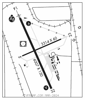
RWY 14–32: H6007X150 (ASPH) S–75, D–100, 2S–127, 2D–150 HIRL
RWY 14: MALSR. VASI(V4L)–GA 3.0° TCH 50′. Tree.
RWY 32: VASI(V4L)–GA 3.0° TCH 32′. Pole.
RWY 05–23: H3314X60 (ASPH) S–42, D–60, 2D–95
RWY 05: Railroad.
RWY 23: Tree.
SERVICE: S3 FUEL 100LL, JET A LGT ACTIVATE MALSR Rwy 14, VASI Rwy 14 and Rwy 32, HIRL Rwy 14–32–CTAF.
AIRPORT REMARKS: Attended 1400–0200Z‡. Migratory flocks of waterfowl invof arpt during the spring and fall of the year. Rwy 23 +35′ p–lines 900′–1050′ from rwy end running 145′ left to 210′ rgt. All acft enter tfc pattern at 1000′ AGL except turbine–powered or large airplanes at 1500′ AGL. Rwy 05–23 asph sfc is in poor cond with raveling and spalling asph, and longl and lateral cracking. Rwy 05 and Rwy 23 mrkgs are faded.
AIRPORT MANAGER: 530-741-6463
WEATHER DATA SOURCES: ASOS 118.475 (530) 742–0695.
COMMUNICATIONS: CTAF/UNICOM 123.05
RCO 122.1R 122.6 110.8T (RANCHO MURIETA RADIO)
®NORCAL APP/DEP CON 125.4
CLEARANCE DELIVERY PHONE: For CD ctc NorCal Apch at 916-361-6874.
AIRSPACE: CLASS E.
RADIO AIDS TO NAVIGATION: NOTAM FILE MYV.
MARYSVILLE (T) (T) VOR/DME 110.8 MYV Chan 45 N39°05.92′ W121°34.38′ at fld. 62/16E.
ILS 110.5 I–MYV Rwy 14. Class IT. Unmonitored. Autopilot coupled apchs NA blw 695′ (1.66 NM fm thld).