MC PHERSON (MPR)(KMPR) 1 SW UTC–6(–5DT) N38°21.14′ W97°41.48′
1498 B NOTAM FILE ICT
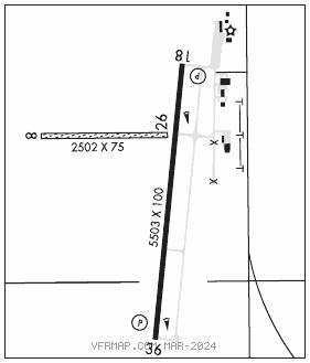
RWY 18–36: H5503X100 (CONC) S–30 PCN 11 R/C/X/U MIRL
RWY 18: REIL. PAPI(P4L)–GA 3.0° TCH 41′. Rgt tfc.
RWY 36: REIL. PAPI(P4L)–GA 3.0° TCH 39′.
RWY 08–26: 2502X75 (TURF)
RWY 26: Rgt tfc.
SERVICE: S4 FUEL 100LL, JET A, MOGAS LGT MIRL Rwy 18–36 preset on med ints, to change ints ACTIVATE–CTAF.
AIRPORT REMARKS: Attended Mon–Fri 1400–2300Z‡, Sat 1400–1800Z‡. 100LL is avbl by use of credit card. Jet A and MOGAS after hrs call manager 620–755–8901. Rwy 08–26 thlds and edges marked by yellow cones. Rwy 18–36 and portions of twys and tie down areas are a combination of concrete and asph. +300′ construction cranes occasionally at refinery 0.9 miles east southeast of arpt.
AIRPORT MANAGER: 620-241-0684
WEATHER DATA SOURCES: AWOS–3P 119.025 (620) 798–1650.
COMMUNICATIONS: CTAF/UNICOM 122.8
RCO 122.6 (WICHITA RADIO)
®WICHITA APP/DEP CON 125.5
CLEARANCE DELIVERY PHONE: For CD if una to ctc on FSS freq, ctc Wichita appch at 316-350-1520
RADIO AIDS TO NAVIGATION: NOTAM FILE HUT.
HUTCHINSON (VL) (L) VORW/DME 116.8 HUT Chan 115 N37°59.82′ W97°56.05′ 024° 24.2 NM to fld. 1542/4E.
VOR unusable:
044°–051° byd 40 NM
140°–143° byd 40 NM
144°–154° byd 40 NM blo 4,500′
144°–154° byd 47 NM
195°–217° byd 16 NM blo 5,000′
195°–217° byd 33 NM blo 8,000′
200°–217° byd 58 NM