MAMMOTH LAKES
MAMMOTH YOSEMITE (MMH)(KMMH) 6 E UTC–8(–7DT) N37°37.44′ W118°50.33′ 7135 B TPA–8007(872) Class I, ARFF Index B NOTAM FILE MMH
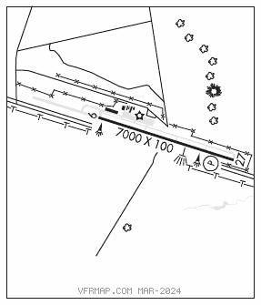
RWY 09–27: H7000X100 (ASPH–GRVD) S–85, D–150 PCN 32 F/B/X/T MIRL 1.0% up W
RWY 27: REIL. PAPI(P4L)–GA 3.0° TCH 45′. Rgt tfc.
RUNWAY DECLARED DISTANCE INFORMATION
RWY 09: TORA–7000 TODA–7000 ASDA–7000 LDA–7000
RWY 27: TORA–7000 TODA–7000 ASDA–7000 LDA–7000
SERVICE: FUEL 100LL, JET A OX 1 LGT ACTIVATE REIL Rwy 27 and MIRL Rwy 09–27–CTAF.
NOISE: NS ABTMT acft arr from the south or dep to the south remain east of highway 395.
AIRPORT REMARKS: Attended 1600–0300Z‡. 100LL fuel avbl 24 hrs, card lock sys. Ngt flying not recommended without knowledge of lcl terrain. No snow removal drg ngt hrs (1630–0700L) wo prior pmsn. Clsd to acr opns of chtr opns, bus jet opns, and scheduled coml opns of acr with more than 30 psgrs and/or wingspans gtr than 79 feet excp 24 hr PPR. Call AMGR 760–965–3654. Apch reference code B/III/5000. Dep reference code B/III. Ridge 3 NM from AER 09. Ridge at Rwy 27 is 304′ abv rwy and 1200′ north of cntrln with haz bcn. 33′ pole lctd 400′ west of AER 27 and 375′ south of Rwy 27 cntrln marked with obst lgt. Arpt lctd in mountainous terrain with ocnl strong winds and turbulence. Lgtd windsock avbl at rwy ends and cntrfld. With southerly crosswinds in excess of 15 kts, exp turbulence and possible windshear along first 3000′ of Rwy 27. Ldg fee.
AIRPORT MANAGER: 760-914-3130
WEATHER DATA SOURCES: AWOS–3 118.05 (760) 934–6020.
COMMUNICATIONS: CTAF/UNICOM 122.8
MAMMOTH LAKES RCO 122.2 (RIVERSIDE RADIO)
®OAKLAND CENTER APP/DEP CON 125.75
CLEARANCE DELIVERY PHONE: For CD if una to ctc on FSS freq, ctc Oakland ARTCC at 510-745-3380.
AIRSPACE: CLASS E.
RADIO AIDS TO NAVIGATION: NOTAM FILE BIH.
BISHOP (L) (L) VORW/DME 113.35 BIH Chan 80(Y) N37°22.62′ W118°21.99′ 288° 27.0 NM to fld. 4117/15E.
VOR unusable:
165°–285° byd 12 NM
305°–315° byd 35 NM
340°–135° byd 12 NM
DME unusable:
165°–285° byd 12 NM
305°–315° byd 35 NM
340°–135° byd 12 NM