KANSAS CITY
CHARLES B WHEELER DOWNTOWN (MKC)(KMKC) 0 NW UTC–6(–5DT) N39°07.38′ W94°35.57′ 757 B LRA Class IV, ARFF Index A NOTAM FILE MKC
RWY 01–19: H6827X150 (CONC–GRVD) S–86, D–171, 2S–175, 2D–342 PCN 67 R/B/W/T HIRL
RWY 01: RLLS. REIL. VASI(V4L)–GA 3.7° TCH 66′. RVR–R Thld dsplcd 299′. Tree.
RWY 19: MALSF. PAPI(P4L)–GA 3.0° TCH 46′. RVR–T Thld dsplcd 302′. Road.
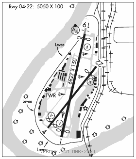
RWY 04–22: H5050X100 (ASPH) S–48, D–73, 2D–136 PCN 74 F/C/W/T HIRL
RWY 04: VASI(V4L)–GA 3.0° TCH 35′. RVR–T Thld dsplcd 500′. Berm.
RWY 22: REIL. VASI(V4L)–GA 3.3° TCH 35′. RVR–R Thld dsplcd 699′. Railroad.
RUNWAY DECLARED DISTANCE INFORMATION
RWY 01: TORA–6827 TODA–6827 ASDA–6827 LDA–6527
RWY 04: TORA–5050 TODA–5050 ASDA–4770 LDA–4270
RWY 19: TORA–6827 TODA–6827 ASDA–6827 LDA–6525
RWY 22: TORA–5050 TODA–5050 ASDA–5050 LDA–4351
ARRESTING GEAR/SYSTEM
RWY 01: EMAS
RWY 19: EMAS
SERVICE: S4 FUEL 100LL, JET A OX 1, 2, 3, 4 LGT Rwy 22 VGSI unusbl byd 8 degs left of crs. Rwy 19 MALSF augmented with RAIL.
AIRPORT REMARKS: Attended continuously. 100LL self svc avbl 24 hrs with credit card only on west side near general aviation terminal. Wildlife on and invof arpt. Flocks of pigeons invof dep EOR 04. Due to obstns, prior to any turns to the E, acft must be at or abv tfc ptn alt. Arpt CLOSED to air carrier ops with more than 30 passenger seats except 24 hr PPR call arpt manager 816–289–2718. Air carrier ops not authorized in excess of 15 minutes before or after scheduled arrival or departure times without prior coordination with arpt manager confirming ARFF avbl prior to landing or takeoff. Rwy 04–22 VFR E tfc pat: departing Rwy 04 right tfc attain tfc pat alt prior to turning crosswind. Ldg Rwy 22 mntn tfc pat alt until passing N of Missouri River. Twr has ltd visibility of T–hangar aprons N of Twy D and W of Twy L. CAUTION: Mult obstructions 0.5 mi–1.0 mi ESE fm Rwy 19 DER up to 290 ft AGL/1100 ft MSL. FAA safety video can be accessed on website. Flight Notification Service (ADCUS) avbl.
AIRPORT MANAGER: (816) 859-7610
WEATHER DATA SOURCES: ASOS 120.75 (816) 329–2843. LAWRS.
COMMUNICATIONS: ATIS 120.75 816–329–2850 UNICOM 122.95
®KANSAS CITY APP/DEP CON 118.4
TOWER 133.3 GND CON 121.9 CLNC DEL 121.9 PRE–TAXI CLNC 121.9
AIRSPACE: CLASS D.
VOR TEST FACILITY (VOT) 108.6
RADIO AIDS TO NAVIGATION: NOTAM FILE MCI.
KANSASCITY (H)(H) VORTACW 113.25 MCI Chan 79(Y) N39°17.12′ W94°44.22′ 140° 11.8 NM to fld. 1017/5E.
NAPOLEON (L) (L) VORTACW 114.0 ANX Chan 87 N39°05.73′ W94°07.73′ 267° 21.7 NM to fld. 878/7E. NOTAM FILE COU.
TACAN AZIMUTH & DME unusable:
220°–230° byd 35 NM blo 2,000′
KENZY NDB (LOM) 344 MK N39°13.25′ W94°33.86′ 192° 6.0 NM to fld.
ILS/DME 111.75 I–GQR Chan 54(Y) Rwy 04. Glideslope unusable for cpd apchs blw 1,013′ MSL.
ILS/DME 109.9 I–MKC Chan 36 Rwy 19. Class IE. LOM KENZY NDB.
COMM/NAV/WEATHER REMARKS: Interference from FM radio station may affect communication in the immediate vicinity of arpt. Freq 121.5 not avbl at twr or FSS.