HARBOR SPRINGS (MGN)(KMGN) 3 E UTC–5(–4DT) N45°25.53′ W84°54.81′
686 B NOTAM FILE MGN
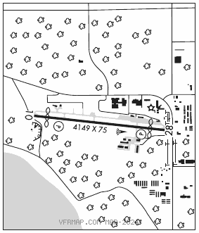
RWY 10–28: H4149X75 (ASPH) S–22, D–30 MIRL
RWY 10: PAPI(P4R)—GA 3.5° TCH 28′. Thld dsplcd 437′. Tree.
RWY 28: PAPI(P4L)—GA 4.0° TCH 35′. Thld dsplcd 444′. Pole.
SERVICE: FUEL 100LL, JET A+ LGT Actvt MIRL Rwy 10–28—CTAF. PAPI Rwy 10 and 28 opr consly. Rwy 28 PAPI unusable byd 2° left of centerline.
NOISE: Noise abatement procedures; no turbojet/turbofan acft deps fm 0400–1200Z‡, no low flight ovr surrounding community, all acft depg to the W turn S ovr the water as soon as practical.
AIRPORT REMARKS: Attended 1300–dusk. Parachute Jumping. Birds and deer on and invof arpt. Rwy 10 apch area has two 70′ lgtd obstruction poles 170′ left of cntrln; +75′ trees on N side. Rwy 28 apch area has lgtd obstruction poles, 165′ left and 220′ right of cntrln; 80′ trees adj. Landing fee waived with minimum fuel purchase.
AIRPORT MANAGER: 231-206-9333
WEATHER DATA SOURCES: AWOS–3P 119.925 (231) 347–5231. Wind spd & drctn unrel btn 260°–280°.
COMMUNICATIONS: CTAF/UNICOM 122.8
®MINNEAPOLIS CENTER APP/DEP CON 134.6
CLEARANCE DELIVERY PHONE: For CD ctc Minneapolis ARTCC at 651-463-5588.
RADIO AIDS TO NAVIGATION: NOTAM FILE PLN.
PELLSTON (L) (L) VORTACW 111.8 PLN Chan 55 N45°37.84′ W84°39.85′ 227° 16.2 NM to fld. 836/6W.
VOR unusable:
301°–339°
GCP has azm only, no DME at GCP