ORLANDO INTL (MCO)(KMCO) P (AF) 6 SE UTC–5(–4DT) N28°25.76′ W81°18.54′
96 B LRA Class I, ARFF Index E NOTAM FILE MCO
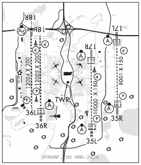
RWY 18L–36R: H12005X200 (ASPH–CONC–GRVD) S–165, D–200, 2S–175, 2D–400 PCN 97 R/B/W/T HIRL CL
RWY 18L: PAPI(P4L)–GA 3.0° TCH 71′. RVR–TMR
RWY 36R: ALSF2. TDZL. PAPI(P4L)–GA 3.0° TCH 70′. RVR–TMR
RWY 18R–36L: H12004X200 (ASPH–CONC–GRVD) S–100, D–200, 2S–175, 2D–400 PCN 104R/B/W/T HIRL CL
RWY 18R: MALSR. TDZL. PAPI(P4L)–GA 3.0° TCH 71′. RVR–TMR
RWY 36L: REIL. PAPI(P4L)–GA 3.0° TCH 69′. RVR–TMR
RWY 17R–35L: H10000X150 (CONC–GRVD) S–75, D–210, 2S–175, 2D–400 PCN 106R/B/W/T HIRL CL
RWY 17R: ALSF2. TDZL. PAPI(P4L)–GA 3.0° TCH 71′. RVR–TMR
RWY 35L: ALSF2. TDZL. PAPI(P4R)–GA 3.0° TCH 72′. RVR–TMR
RWY 17L–35R: H9001X150 (CONC–GRVD) S–75, D–210, 2D–420, 2D/2D2–900 PCN 116R/B/W/T HIRL CL
RWY 17L: ALSF2. TDZL. PAPI(P4L)–GA 3.0° TCH 72′. RVR–TMR
RWY 35R: ALSF2. TDZL. PAPI(P4R)–GA 3.0° TCH 73′. RVR–TMR
RUNWAY DECLARED DISTANCE INFORMATION
RWY 17L:TORA–9001 TODA–9001 ASDA–9001 LDA–9001
RWY 17R:TORA–10000TODA–10000 ASDA–10000 LDA–10000
RWY 18L:TORA–12005 TODA–12005 ASDA–12005 LDA–12005
RWY 18R:TORA–12004TODA–12004 ASDA–12004 LDA–12004
RWY 35L:TORA–10000 TODA–10000 ASDA–10000 LDA–10000
RWY 35R:TORA–9001 TODA–9001 ASDA–9001 LDA–9001
RWY 36L:TORA–12004 TODA–12004 ASDA–11621 LDA–11621
RWY 36R:TORA–12005TODA–12005 ASDA–11601 LDA–11601
SERVICE: S2 FUEL 100LL, JET A LGT Rwy 17L–35R TDZL unlit 0400–1100Z‡. MILITARY–FUEL A, A+ (C407–851–8304.) (NC–100LL)
AIRPORT REMARKS: Attended continuously. Birds and deer on and invof arpt. Use caution invof Twy A along west ramp. Rwy 18L–36R ctr 75′ keel section of rwy conc full length, ctr 100′ keel section of rwy conc first 1000′, both ends. Rest of rwy width is asph. Rwy 18R–36L ctr 87′ keel section of rwy conc full length, rest of rwy width is asph. Last 3000′ of Rwy 18R is conc full width. ASDE–X in use. Operate transponders with altitude reporting mode and ADS–B (if equipped) enabled on all airport surfaces. Unless advised by ATIS, dep flts on initial ctc with GND CON, acft on West ramp, Airside 1 and 3 (Gates 1–59) use GND CON 121.8. Acft at Airside 2 and 4 (Gates 60 and higher), use GND CON 126.4. When ORL ILS Rwy 07 and MCO ILS Rwys 17 and 18R simultaneous ops are conducted, ATC radar rqrd. Bright lgts on road btn Rwy 17R–35L and Rwy 17L–35R may be mistaken for rwy lgts. Acft with wingspan greater than 214′ must adhere to specific rwy and taxi rts. Ctc afld ops at 407–825–2036 for details. Rwy status lgts are in opr. Avoid ctc with twy edge lgts, all acft determined to be FAA Design Group IV and abv must perform judgmental oversteering instead of cockpit cntrln steering when taxiing. Twy J3 and Twy J4 rstd to wingspan of less than 118′. Twy A, south of Twy A3, rstd to wingspan of less than 118′. PPR rqr for wingspan 118′ or greater. West ramp customs inspection parking area rstd to acft wingspan less than 118′. Twy A, btn W ramp S end and Twy B10, rstd to acft wingspan less than 171′. PPR for acft wingspan 171′ or greater. Flight Notification Service (ADCUS) avbl.
AIRPORT MANAGER: 407-825-7445
WEATHER DATA SOURCES: ASOS (407) 855–5235 LLWAS. TDWR.
COMMUNICATIONS: D–ATIS ARR 121.25 D–ATIS DEP 120.525 UNICOM 122.95
®ORLANDO APP/DEP CON 119.4 (181°–310° 5500′ and blo) 119.4 (061°–180° 4500′ and blo) 135.3 (311°–060° 5500′ and blo) 120.15 (181°–359° abv 5500′) 124.8 (000°–180° abv 5000′)
TOWER 124.3 (Rwy 18L–36R; Rwy 18R–36L) 118.45 (Rwy 17L–35R; Rwy 17R–35L)
GND CON 121.8 (West) 126.4 (East) CLNC DEL 134.7
CPDLC (LOGON KUSA) AR OPS 41.5 148.8
PDC
AIRSPACE: CLASS B See VFR Terminal Area Chart.
RADIO AIDS TO NAVIGATION: NOTAM FILE ORL.
(VH) (H) VORTACW 112.2 ORL Chan 59 N28°32.56′ W81°20.10′ 169° 6.9 NM to fld. 102/0E.
TACAN AZIMUTH unusable:
066°–084°
246°–289° byd 17 NM blo 2,000′
246°–289° byd 28 NM blo 2,500′
VOR unusable:
075°–089° byd 40 NM blo 8,000′
075°–089° byd 53 NM
090°–100° byd 40 NM
235°–245° byd 40 NM
260°–296° byd 40 NM blo 2,000′
260°–296° byd 46 NM blo 5,000′
260°–296° byd 57 NM
300°–314° byd 40 NM blo 4,000′
300°–314° byd 55 NM blo 6,000′
300°–314° byd 66 NM
320°–330° byd 40 NM
340°–345° byd 40 NM
ILS/DME 110.95 I–ARK Chan 46(Y) Rwy 17L. Class IIIE.
ILS/DME 111.75 I–DIZ Chan 54(Y) Rwy 17R. Class IIE.
ILS/DME 111.9 I–TFE Chan 56 Rwy 18R. Class IA.
ILS/DME 110.5 I–DDO Chan 42 Rwy 35L. Class IIIE.
ILS/DME 111.15 I–CER Chan 48(Y) Rwy 35R. Class IIIE.
ILS/DME 110.7 I–OJP Chan 44 Rwy 36R. Class IIIE.