KANSAS CITY INTL (MCI)(KMCI) 15 NW UTC–6(–5DT) N39°17.86′ W94°42.83′
1027 B LRA Class I, ARFF Index C NOTAM FILE MCI
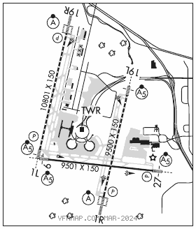
RWY 01L–19R: H10801X150 (ASPH–GRVD) S–120, D–250, 2D–524, 2D/2D2–450 PCR 1106 R/D/W/T HIRL CL
RWY 01L: MALSR. TDZL. PAPI(P4L)–GA 3.0° TCH 78′. RVR–TMR 0.4% down.
RWY19R: ALSF2. TDZL. PAPI(P4R)–GA 3.0° TCH80′. RVR–TMR Rgt tfc. 0.3% up.
RWY 09–27: H9501X150 (ASPH–GRVD) S–120, D–250, 2D–465, 2D/2D2–260 PCR 646 F/B/X/T HIRL
RWY 09: MALSR. RVR–TR
RWY 27: MALSR. PAPI(P4L)–GA 3.0° TCH 72′. RVR–TR Rgt tfc. 0.3% down.
RWY 01R–19L: H9500X150 (CONC–GRVD) S–75, D–204, 2S–175, 2D–400, 2D/2D2–450 PCN 71 R/B/W/T HIRL CL
RWY 01R: ALSF2. TDZL. PAPI(P4R)–GA 3.0° TCH 74′. RVR–TMR
RWY 19L: MALSR. TDZL. RVR–TMR 0.6% up.
RUNWAY DECLARED DISTANCE INFORMATION
RWY 01L:TORA–10801 TODA–10801 ASDA–10801 LDA–10801
RWY 01R:TORA–9500 TODA–9500 ASDA–9500 LDA–9500
RWY 09: TORA–9501 TODA–9501 ASDA–9501 LDA–9501
RWY 19L:TORA–9500 TODA–9500 ASDA–9500 LDA–9500
RWY 19R:TORA–10801TODA–10801 ASDA–10801 LDA–10801
RWY 27: TORA–9501 TODA–9501 ASDA–9501 LDA–9501
SERVICE: FUEL 100LL, JET A
NOISE: Noise abatement procedures in effect 0400–1200Z‡ with landing on Rwys 01L and 19L; takeoffs on Rwys 01R and 19R.
AIRPORT REMARKS: Attended continuously. Waterfowl on and invof arpt. ASSC in use. Operate transponders with altitude reporting mode and ADS–B (if equipped) enabled on all airport surfaces. Ctl twr has limited visibility on numerous gates at all 3 terminals. Windshear alert system on arpt. When using hi–speed exits C5 and C6 continue until first parallel twy, then use extreme care when turning in excess of 90 degrees. Design group V and VI rqr an arpt escort on Twy D between Twy J and Twy L. Twy B1 btn Twy B and FEDEX apron; cockpit over cntrln steering required. PPR to park at airline gates ctc respective airline. No acft parking on postal apron. Flight Notification Service (ADCUS) avbl at gate 90. Military acft may be charged ramp/parking fees. Twy L btn Twy L1 and Twy D wingspan restriction of 118′. Twy C2 btn Twy C3 and Twy C1 wingspan restriction of 118′. Txl W, N1, N3, M1, M3, S1, S3 wingspan restrictions of 118 ft.
AIRPORT MANAGER: 816-243-5248
WEATHER DATA SOURCES: ASOS (816) 329–2808 LLWAS. TDWR.
COMMUNICATIONS: D–ATIS 128.375 816–329–2725 UNICOM 122.95
RCO 122.5 (COLUMBIA RADIO)
®APP CON 120.95
INTERNATIONAL TOWER 128.2 GND CON 121.8 CLNC DEL 135.7
®DEP CON 124.7 (191°–009°) 123.95 (010°–190°)
N RAMP CTRL 128.975 S RAMP CTRL 130.825
CPDLC (LOGON KUSA)
PDC
AIRSPACE: CLASS B See VFR Terminal Area Chart.
RADIO AIDS TO NAVIGATION: NOTAM FILE MCI.
(H) (H) VORTACW 113.25 MCI Chan 79(Y) N39°17.12′ W94°44.22′ 051° 1.3 NM to fld. 1017/5E.
ILS/DME 110.5 I–DOT Chan 42 Rwy 01L. Class IT.
ILS/DME 110.75 I–PVL Chan 44(Y) Rwy 01R. Class IIIE.
ILS/DME 109.7 I–RNI Chan 34 Rwy 09. Class IB.
ILS/DME 109.55 I–DYH Chan 32(Y) Rwy 19L. Class IE.
ILS/DME 109.1 I–PAJ Chan 28 Rwy 19R. Class IIIE.
ILS/DME 109.7 I–UQY Chan 34 Rwy 27. Class IE.