MACKINAC ISLAND (MCD)(KMCD) 1 NW UTC–5(–4DT) N45°51.90′ W84°38.23′
741 B TPA—1900(1159) NOTAM FILE MCD
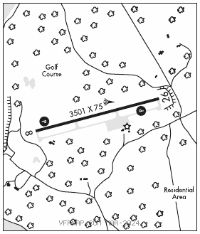
RWY 08–26: H3501X75 (ASPH–PFC) S–13 MIRL 0.4% up E
RWY 08: REIL. PAPI(P4L)—GA 3.5° TCH 20′. Tree.
RWY 26: REIL. PAPI(P4L)—GA 3.8° TCH 38′. Tree.
SERVICE: LGT Actvt REIL Rwys 08 and 26; PAPI Rwy 08 and 26; MIRL Rwy 08–26—122.8. Rwy 08 PAPI unusbl byd 5 degs left of ccntrln. Rwy 26 PAPI unusbl byd 5 degs left of ccntrln.
NOISE: Noise abatement procs: climb to TPA bfr turning; avd flt ovr shore & town; TGL NA.
AIRPORT REMARKS: Attended 1300–2200Z‡. Lrg birds on & invof arpt; flocks of seagulls invof landfill 0.3 NM NE. Obstn lgts are in the apch to Rwy 26. Ldg fee. Pitot covs rcmdd while parked; ck tubes bfr dep due to mud daubers.
AIRPORT MANAGER: 906-847-3231
WEATHER DATA SOURCES: AWOS–3 118.275 (906) 847–3778.
COMMUNICATIONS: CTAF/UNICOM 122.7
®MINNEAPOLIS CENTER APP/DEP CON 134.6
CLEARANCE DELIVERY PHONE: For CD ctc Minneapolis ARTCC at 651-463-5588.
RADIO AIDS TO NAVIGATION: NOTAM FILE PLN.
PELLSTON (L) (L) VORTACW 111.8 PLN Chan 55 N45°37.84′ W84°39.85′ 011° 14.1 NM to fld. 836/6W.
VOR unusable:
301°–339°
GCP has azm only, no DME at GCP