LEADVILLE
LAKE CO (LXV)(KLXV) 2 SW UTC–7(–6DT) N39°13.17′ W106°18.99′ 9934 B NOTAM FILE LXV
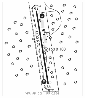
RWY 16–34: H6400X75 (ASPH) S–20, D–20 MIRL
RWY 16: PAPI(P2L)–GA 3.0° TCH 45′. Rgt tfc.
RWY 34: PAPI(P2L)–GA 3.0° TCH 45′.
SERVICE: FUEL 100LL, JET A LGT ACTVT PAPI RWY 16 and RWY 34; MIRL RWY 16–34–CTAF.
AIRPORT REMARKS: Attended May–Sep 1430–2330Z‡, Oct–Apr 1500–2330Z‡. PPR for svc after hrs call 719–427–0026. Rwy 34 has +50′ power lines 750′ from right of thld. Twy C and old ramp have potholes and loose aggregate. All twys and new ramp area marked with blue and white reflectors.
AIRPORT MANAGER: 719-486-0307
WEATHER DATA SOURCES: ASOS 118.375 (719) 486–8441.
COMMUNICATIONS: CTAF/UNICOM 122.8
®DENVER CENTER APP/DEP CON 119.85
CLEARANCE DELIVERY PHONE: For CD ctc Denver ARTCC at 303-651-4257.
RADIO AIDS TO NAVIGATION: NOTAM FILE DEN.
RED TABLE (VH) (DH) VORW/DME 113.0 DBL Chan 77 N39°26.36′ W106°53.68′ 104° 30.0 NM to fld. 1180012E.
VOR unusable:
040°–056° byd 40 NM
057°–074° byd 40 NM blo 16,300′
057°–074° byd 65 NM
075°–100° byd 40 NM
115°–130° byd 40 NM
160°–200° byd 40 NM
• • • • • • • • • • • • • • • • • •
HELIPAD H1: H150X100 (ASPH–CONC)
HELIPORT REMARKS: Helipad H1 has 20–30 ft trees 130 ft east of pad. Helipad H1 has 6–8 inch lip all around edges, concrete has longitudinal and corner cracking.