PEARLAND RGNL (LVJ)(KLVJ) 17 S UTC–6(–5DT) N29°31.28′ W95°14.53′
44 B NOTAM FILE LVJ
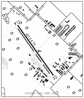
RWY 14–32: H4313X75 (CONC) S–30 MIRL
RWY 14: Trees.
RWY 32: Road.
SERVICE: S4 FUEL 100LL, JET A LGT MIRL Rwy 14–32 SS–SR preset low intst; incr intst and actvt—CTAF.
AIRPORT REMARKS: Attended 1400–01000Z‡. Banner towing SR–SS. Hel traffic invof arpt. Rwy 14 and Rwy 32 hels use right–hand traffic. Rwy 14 calm wind rwy. Lgtd oil derrick 116′ AGL, 0.65 NM southeast of arpt. Rwy 14 25 ft lgtd poles in trees 520 ft fm thr. Rwy 14–32 safety area ireg sfc irrigation ditches E and W side adj 40′, 10′ drop.
AIRPORT MANAGER: 281-482-7551
WEATHER DATA SOURCES: ASOS 118.525 (281) 992–1853.
COMMUNICATIONS: CTAF/UNICOM 122.725
®HOUSTON APP/DEP CON 134.45
CLNC DEL 124.0
CLEARANCE DELIVERY PHONE: For CD ctc Houston Apch at 281-443-5844. to cnl IFR ctc Houston Apch at 281-443-5888.
RADIO AIDS TO NAVIGATION: NOTAM FILE GLS.
SCHOLES (VH) (DH) VORW/DME 113.0 VUH Chan 77 N29°16.16′ W94°52.06′ 302° 24.7 NM to fld. 4/6E.
VOR unusable:
285°–295° byd 35 NM blo 2,500′