DECATUR MUNI (LUD)(KLUD) 2 N UTC–6(–5DT) N33°15.26′ W97°34.83′
1047 B NOTAM FILE LUD
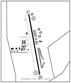
RWY 17–35: H4200X60 (ASPH) S–12.5, D–17 MIRL
RWY 17: REIL. PAPI(P2L)–GA 3.5° TCH 23′. Tree.
RWY 35: PAPI(P2L)–GA 3.5° TCH 40′. P–line. Rgt tfc.
SERVICE: S4 FUEL 100LL, JET A LGT Dusk–Dawn. MIRL Rwy 17–35 preset low intst; to incr intst actvt–CTAF.
AIRPORTREMARKS:Attended 1400–2300Z‡. Deer and wildlife on and invof arpt. Gnd drops sharply 160′ north of Rwy 17 thr. Rwy 17–35 extensive pavement cracking. Due to rwy elev chg, acft not vsb at opposite end.
AIRPORT MANAGER: 940-627-2855
WEATHER DATA SOURCES: AWOS–3 118.225 (940) 627–2365.
COMMUNICATIONS: CTAF/UNICOM 122.8
®REGIONAL APP/DEP CON 118.1
CLEARANCE DELIVERY PHONE: For CD ctc Regional Apch at 972-615-2799.
RADIO AIDS TO NAVIGATION: NOTAM FILE FTW.
BOWIE (H) (H)VORTACW 117.15 UKW Chan 118(Y) N33°32.15′ W97°49.28′ 138° 20.8 NM to fld. 1102/6E.