HARRISONVILLE
LAWRENCE SMITH MEML (LRY)(KLRY) 3 S UTC–6(–5DT) N38°36.61′ W94°20.61′ 915 B NOTAM FILE COU
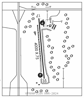
RWY 17–35: H4000X75 (ASPH) S–12.5 MIRL 1.0% up N
RWY 17: PAPI(P4L)–GA 4.0° TCH 53′. Trees.
RWY 35: PAPI(P4L)–GA 3.0° TCH 47′. Trees.
RUNWAY DECLARED DISTANCE INFORMATION
RWY 17: TORA–4000 TODA–4000 ASDA–4000 LDA–4000
RWY 35: TORA–4000 TODA–4000 ASDA–4000 LDA–4000
SERVICE: S2 FUEL 100LL LGT Actvt PAPI Rwy 17 and 35; MIRL Rwy 17–35–CTAF.
AIRPORT REMARKS: Attended Mon–Fri 1400–2300Z‡, Sat–Sun irregularly. Deer and other wildlife on and invof arpt. Ultralights on and invof arpt. Air ambulance helicopter ops on and invof arpt. 24–hr self svc fuel. Rwy 17–35 has extsv cracking.
AIRPORT MANAGER: (660) 422-2090
WEATHER DATA SOURCES: AWOS–3PT 119.975 (816) 380–5936.
COMMUNICATIONS: CTAF/UNICOM 123.0
®KANSAS CITY CENTER APP/DEP CON 125.55
CLEARANCE DELIVERY PHONE: For CD ctc Kansas City Apch at 816-329-2710.
RADIO AIDS TO NAVIGATION: NOTAM FILE COU.
BUTLER (VH) (H) VORTAC 115.9 BUM Chan 106 N38°16.32′ W94°29.30′ 012° 21.4 NM to fld. 8907E.
VOR unusable:
083°–093° byd 40 NM blo 13,500′
249°–259° byd 40 NM blo 18,000′
295°–305° byd 49 NM