LONGMONT
VANCE BRAND (LMO)(KLMO) 3 SW UTC–7(–6DT) N40°09.86′ W105°09.82′ 5055 B NOTAM FILE DEN
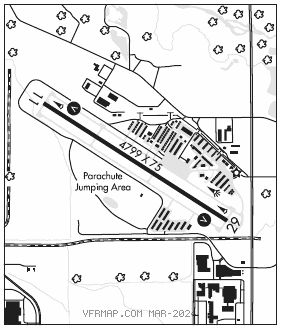
RWY 11–29: H4799X75 (CONC) S–30 MIRL 0.5% up NW
RWY 11: VASI(V2L)–GA 3.0° TCH 24′. Tree.
RWY 29: VASI(V2L)–GA 3.0° TCH 35′. Road.
SERVICE: S4 FUEL 100LL, JET A, MOGAS LGT ACTIVATE MIRL Rwy 11–29 and VASI Rwy 11 and Rwy 29–CTAF. Rwy 11 VASI unusable byd 3.9 NM. VASI does not provide obst clnc byd 3.9 NM from thld.
NOISE: Noise abatement procedures in effect ctc arpt manager 303–651–8431.
AIRPORTREMARKS: Attended dalgt hrs. Parachute jumping on and invof arpt primarily of rwy, avoid overflights mid fld. Ultralight and helicopter activity on and invof arpt. Rwy 29 has +15′ highway 702′ from thld, +25′ to 35′ bldgs/tanks aprx 1300′ left of thld. NOTE: See Special Notices–Aerobatic Operations in Colorado, USAF 306 FTG Flight Training Areas, Vicinity of Colorado Springs and Pueblo Colorado.
AIRPORT MANAGER: 303-651-8431
WEATHER DATA SOURCES: AWOS–3 120.0 (303) 684–7545.
COMMUNICATIONS: CTAF/UNICOM 122.975
®DENVER APP/DEP CON 125.12
CLEARANCE DELIVERY PHONE: For CD ctc Denver Apch at 303-342-1916.
RADIO AIDS TO NAVIGATION: NOTAM FILE BJC.
JEFFCO (VH) (DH) VORW/DME 115.4 BJC Chan 101 N39°54.78′ W105°08.34′ 345° 15.1 NM to fld. 5737/11E.
VOR unusable:
180°–225° byd 40 NM
226°–245° byd 36 NM blo 17,000′
246°–278° byd 30 NM blo 19,000′
279°–300° byd 34 NM blo 18,000′
301°–335° byd 40 NM
DME unusable:
246°–278° byd 30 NM