LONG BEACH (DAUGHERTY FLD) (LGB)(KLGB) 3 NE UTC–8(–7DT) N33°49.08′ W118°09.11′
60 B Class I, ARFF Index C NOTAM FILE LGB MON Airport
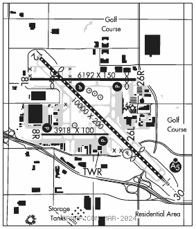
RWY 12–30: H10000X200 (ASPH–GRVD) S–30, D–200, 2S–175, 2D–300 PCN 62 F/A/X/T HIRL CL
RWY 12: REIL. PAPI(P4L)–GA 3.0° TCH 70′. RVR–R Thld dsplcd 1350′. Fence. 0.4% down.
RWY 30: MALSR. TDZL. PAPI(P4L)–GA 3.0° TCH 64′. RVR–T Thld dsplcd 2000′. Tree. 0.3% up.
RWY 08L–26R: H6192X150 (ASPH–GRVD) S–30, D–70, 2D–110 PCN 54 F/B/W/T MIRL
RWY 08L: Thld dsplcd 1305′. Pole.
RWY 26R: REIL. PAPI(P4L)–GA 3.1° TCH 62′. Thld dsplcd 532′. Road. Rgt tfc.
RWY 08R–26L: H3918X100 (ASPH) S–30, D–75 PCN 61 F/C/X/U HIRL 0.5% up W
RWY 08R: REIL. PAPI(P4L)–GA 3.0° TCH 38′. Tower. Rgt tfc.
RWY 26L: REIL. PAPI(P4L)–GA 3.0° TCH 34′. Trees.
LAND AND HOLD–SHORT OPERATIONS
LDG RWY HOLD–SHORT POINT AVBL LDG DIST
RWY 26R 12–30 3400
RWY 30 08L–26R 5850
RUNWAY DECLARED DISTANCE INFORMATION
RWY 08L:TORA–6192 TODA–6192 ASDA–6192 LDA–4887
RWY 08R:TORA–3918 TODA–3918 ASDA–3918 LDA–3918
RWY 12: TORA–10000 TODA–10000 ASDA–10000 LDA–8650
RWY 26L:TORA–3918 TODA–3918 ASDA–3918 LDA–3918
RWY 26R:TORA–6192 TODA–6192 ASDA–6192 LDA–5660
RWY 30: TORA–10000 TODA–10000 ASDA–9414 LDA–7414
SERVICE: S4 FUEL 100LL, JET A OX 1, 2, 3, 4 LGT When twr clsd ACTIVATE MALSR Rwy 30, REIL Rwy 08R, 12, 26L and Rwy 26R, PAPI Rwy 12, 08R, 26L and Rwy 26R; HIRL Rwy 08R–26L; MIRL Rwy 08L–26R–CTAF. HIRL, TDZL and CL lgts Rwy 12–30 opr continuously when twr clsd. PAPI Rwy 30 opr continuously.
NOISE: 24 hr PN reqd for mil jets and civ Non–Stage III Jets, ctc NS ABTMT 562–570–2635 or freq 122.85 Mon–Fri 1530–0030Z‡. NS ABTMT info on 122.85. Noise limits (decibels single event noise exposure level), Rwy 26R tkf 92.0–ldg 88.0, Rwy 08L tkf 88.0–ldg 92.0, Rwy 26L tkf 95.0 ldg 93.0, Rwy 08R tkf 95.0 ldg 92.0. Rwy 12 and 30 1500–0600Z‡ tkf 102.5 ldg 101.5, 1400–1500Z‡ and 0600–0700Z‡ tkf 90.0 ldg 90.0, 0700–1400Z‡ tkf 79.0 ldg 79.0. Touch and go, stop and go, practic low apch, VFR practice missed apch only pmtd 1500–0300Z‡ wkdays and 1600–2300Z‡ wkends and hols only on Rwys 08L–26R and 08R–26L. Engine run–ups other than preflt are ltd to hrs of 1500–0500Z‡ weekdays and 1700–0500Z‡ weekends and hol.
AIRPORT REMARKS: Attended continuously. All rwys CLOSED 0600–1500Z‡ exc Rwy 12–30. No fld condition NOTAMs avbl 0600–1500Z‡. Birds on and invof arpt. Airships moored in infld and opr invof arpt. Rwy 08R lgtd tower 152 ft AGL 2500 ft west and 500 ft south of ry thld. 6′ lgtd chain link fence lctd 130′ South of cntrln of Twy F. Fence begins NW corner of twr and extends 400′ to West. Rwy 08R–26L not avbl for sked acr opns with more than 9 psgr seats or unsked acr opns with at least 31 psgr seats. Rwy 12–30 max ldg weights A–330 347,000 lbs, A–340 379,000 lbs, DC–10–10, DC 10 3040 and MD–11 379,000 lbs–1011 354,000 lbs. Max tkf weights DC–10 3040 and MD–11 588,100 lbs, C–17 538,600 lbs. Max ldg weight for C–17 at or byd GS or rwy aiming point marking 538,600 lbs. Rwy 30 ldg prior to rwy aiming point marking 344,000 lbs. All acft on or entering left downwind Rwy 26L must remain north of signal hill unless specifically instructed by ATC otherwise. All acft on downwind Rwy 26L are not authorized to turn base or begin decent until east of Rwy 30 unless specifically instructed to do so by ATC. All acft on downwind Rwy 08L are not authorized to turn base or begin decent until west of Rwy 12 unless specifically instructed to do so by ATC. Twy D3 and L3 weight limits A–340, DC–10 3040 and MD–11 541,000 lbs, C–17 450,000 lbs. No twy access to Rwy 08L West of Twy D, 4897′ remaining on Rwy 08L from Twy D. NOTE: See Special Notices – Air Carrier Operations Vicinity of Long Beach (Daugherty Fld), CA.
AIRPORT MANAGER: (562) 570-2605
WEATHER DATA SOURCES: ASOS (562) 424–0572
COMMUNICATIONS: CTAF 119.4 ATIS 127.75 562–595–8564 UNICOM 122.95
®SOCAL APP CON 125.35
TOWER 119.4 (Rwy 30 apch, Rwy 12 dep) 120.5 (Rwy 12 apch, Rwy 30 dep) (1415–0745Z‡)
®SOCAL DEP CON 127.2
GND CON 133.0 CLNC DEL 118.15
CLEARANCE DELIVERY PHONE: For CD when ATCT clsd ctc SoCal Apch at 800-448-3724.
AIRSPACE: CLASS D svc 1415–0745Z‡; other times CLASS G.
VOR TEST FACILITY (VOT) 113.9
RADIO AIDS TO NAVIGATION: NOTAM FILE SLI.
SEAL BEACH (VL) (L) VORTACW 115.7 SLI Chan 104 N33°47.00′ W118°03.29′ 278° 5.3 NM to fld. 22/15E.
VOR unusable:
017°–027° byd 40 NM blo 18,000′
028°–038° byd 40 NM
075°–085° byd 40 NM blo 8,000′
075°–085° byd 48 NM blo 11,000′
075°–085° byd 65 NM
086°–123° byd 40 NM
124°–134° byd 40 NM blo 4,000′
124°–134° byd 48 NM
125°–180° byd 30 NM blo 4,000′
135°–145° byd 40 NM
183°–193° byd 40 NM
245°–256° byd 40 NM blo 5,500′
245°–256° byd 57 NM
278°–282° byd 40 NM
321°–016° byd 40 NM
TACAN AZIMUTH unusable:
125°–195° byd 20 NM blo 5,000′
DME unusable:
125°–195° byd 20 NM blo 5,000′
ILS 110.3 I–LGB Rwy 30. Class IE. Unmonitored when LGB ATCT closed.
• • • • • • • • • • • • • • • • • •
HELIPAD H2: H20X20 (ASPH)
HELIPAD H3: H300X35 (ASPH)
HELIPAD H4: H20X20 (ASPH)
HELIPAD H5: H20X20 (ASPH)
HELIPORT REMARKS: Trng helipads H2, H3 and H4 lctd N of Rwy 12–30 midfield btn Twys G and K. Trng helipad H5 lctd S of Rwy 12–30 btn Twys D and J for hover work only. Helipad H2, H4 and H5 20 X 20 asph. Helipad H3 35 X 300 asph. No running ldgs/tkofs by helicopters with skid–type ldg gear on Rwy 08L–26R. Rolling ldgs/tkofs with helicopters with wheel–type ldg gear are permitted.