TEXAS GULF COAST RGNL (LBX)(KLBX) 4 SW UTC–6(–5DT) N29°06.52′ W95°27.73′
25 B Class IV, ARFF Index A NOTAM FILE LBX
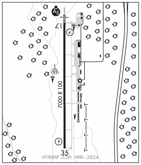
RWY 17–35: H7000X100 (CONC–GRVD) S–60, D–95, 2S–120, 2D–120 MIRL
RWY 17: MALSR. PAPI(P4L)—GA 3.0° TCH 52′. Rgt tfc.
RWY 35: PAPI(P4L)—GA 3.0° TCH 40′.
RUNWAY DECLARED DISTANCE INFORMATION
RWY 17: TORA–7000 TODA–7000 ASDA–7000 LDA–7000
RWY 35: TORA–7000 TODA–7000 ASDA–7000 LDA–7000
SERVICE: S6 FUEL 100LL, JET A OX 4 LGT MIRL Rwy 17–35 preset low intst; to incr intst and ACTVT MALSR Rwy 17—CTAF. PAPI Rwys 17 and 35 opr consly.
AIRPORT REMARKS: Attended Mon–Fri 1230–0030Z‡, Sat–Sun 1400–0030Z‡. 100LL fuel avbl 24 hrs self service. For Jet A fuel after hrs call 979–319–2740. Arpt located 4.6 NM NW of Lake Jackson. Air carrier ops involving acft with more than 30 passengers are not authorized in excess of 15 min before or after scheduled arrival or departure times without prior coordination with arpt manager and confirmation that ARFF svcs are avbl prior to ldg or tkf.
AIRPORT MANAGER: 979-849-5755
WEATHER DATA SOURCES: ASOS 119.925 (979) 849–3319.
COMMUNICATIONS: CTAF/UNICOM 123.0
®HOUSTON APP/DEP CON 134.45
CLNC DEL 125.2
CLEARANCE DELIVERY PHONE: For CD ctc Houston Apch at 281-443-5844. To cnl IFR ctc Houston Apch at 281-443-5888.
RADIO AIDS TO NAVIGATION: NOTAM FILE GLS.
SCHOLES (VH) (DH) VORW/DME 113.0 VUH Chan 77 N29°16.16′ W94°52.06′ 247° 32.7 NM to fld. 4/6E.
VOR unusable:
285°–295° byd 35 NM blo 2,500′
ILS/DME 109.1 I–LBX Chan 28 Rwy 17. Class IE.