LOS ANGELES
LOS ANGELES INTL (LAX)(KLAX) P (AF CG) 9 SW UTC–8(–7DT) N33°56.55′ W118°24.48′ 128 B LRA Class I, ARFF Index E NOTAM FILE LAX
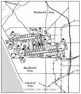
RWY 07L–25R: H12923X150 (CONC–GRVD) S–175, D–225, 2D–400, 2D/2D2–900 PCN 70 R/A/W/T HIRL CL
RWY 07L: MALSR. TDZL. PAPI(P4L)–GA 3.0° TCH 83′. RVR–TMR Thld dsplcd 832′. Rgt tfc.
RWY 25R: MALSR. PAPI(P4L)–GA 3.0° TCH 75′. RVR–TMR Thld dsplcd 957′. Railroad. 0.3% up.
RWY 07R–25L: H11095X200 (ASPH–CONC–GRVD) S–175, D–225, 2D–400, 2D/2D2–900 PCN 75 R/A/W/T HIRL CL
RWY07R: MALSR. PAPI(P4L)–GA 3.0° TCH 57′. RVR–TMR Pole. Rgt tfc.
RWY 25L: ALSF2. TDZL. PAPI(P4R)–GA 3.0° TCH 70′. RVR–TMR Railroad. 0.3% up.
RWY 06R–24L: H10885X150 (CONC–GRVD) S–175, D–225, 2D–400, 2D/2D2–900 PCN 70 R/A/W/T HIRL CL
RWY 06R: MALSR. TDZL. PAPI(P4L)–GA 3.0° TCH 69′. RVR–TMR Thld dsplcd 537′. Pole.
RWY 24L: MALSR. PAPI(P4R)–GA 3.0° TCH 79′. RVR–TMR Thld dsplcd 801′. Rgt tfc.
RWY 06L–24R: H8926X150 (ASPH–CONC–GRVD) S–175, D–225, 2D–400, 2D/2D2–900 PCN 70 R/A/W/T HIRL CL
RWY 06L: MALSR. PAPI(P4L)–GA 3.0° TCH 77′. RVR–TMR Pole.
RWY 24R: ALSF2. TDZL. PAPI(P4L)–GA 3.0° TCH 73′. RVR–TMR Sign. Rgt tfc.
RUNWAY DECLARED DISTANCE INFORMATION
RWY 06L:TORA–8926 TODA–8926 ASDA–8566 LDA–8566
RWY 06R:TORA–10285TODA–10285 ASDA–10285 LDA–9748
RWY 07L:TORA–12091 TODA–12091 ASDA–12091 LDA–11259
RWY 07R:TORA–11095TODA–11095 ASDA–11095 LDA–11095
RWY 24L:TORA–10285 TODA–10285 ASDA–10285 LDA–9483
RWY 24R:TORA–8926 TODA–8926 ASDA–8926 LDA–8926
RWY 25L:TORA–11095 TODA–11095 ASDA–11095 LDA–11095
RWY 25R:TORA–12091TODA–12091 ASDA–12091 LDA–11134
SERVICE: S4 FUEL JET A OX 1, 3 LGT Rwy 24R ALSF2 operates as SSALR until weather goes below VFR. Rwy 25L ALSF2 operates as SSALR till weather goes below VFR. MILITARY– FUEL A, A+ (C310–258–9884) FLUID LHOX
NOISE: Noise sensitive arpt, on westerly tkfs no turns before crossing shoreline, over–ocean apchs utilized 0800–1430Z‡. NOTE: See Special Notices–Noise Abatement Procedures.
AIRPORT REMARKS: Attended continuously. Rwy 07R–25L preferred emerg rwy. Numerous birds on and invof airport. Pilots should use ctn for poss laser act in the LAX area. Turbulence may be deflected upward from the blast fence 180′ east of Rwy 25R. Major construction on arpt daily. American Eagle terminal southbound taxing acft use minimum power due to blast hazard. Any acft that comes to a stop, or has its momentum interrupted while turning and taxiing into its parking position, must stop and be towed. Acft use minimum power when taxiing vicinity terminals due blast hazard. Sbnd turn not avbl from west remote gate 408 and west remote gate 409. ASDE–X in use. Operate transponders with altitude reporting mode and ADS–B (if equipped) enabled on all airport surfaces. Practice instrument approaches and touch and go landings are prohibited. Acft with wingspan greater than 155 ft wb on Txl C are not auth to make left turn on Twy C10 under pwr. For acft with wingspan greater than 214′ ctc LAX airside ops 424–646–5292 for arpt instructions. Twy D between Twy D7 and D8 (north of terminal one) clsd to acft with wingspan greater than 157′. Acft with wingspan gtr than 198 ft obnd fm Txl D8 may not turn wbnd onto Txl D. Acft with length greater than 240′ are prohibited on Taxilanes C7, C8 and C9 btn Taxilane C and Twy B. West remote gates: acft use of open gates as taxi path is prohibited (gates 406, 407, 408, 409). Simul acft ops prohibited on Twys L and H9 btwn Rwys 07L–25R and Rwy 07R–25L. Simultaneous acft ops prohibited on Twy H2 and Twy G between Rwy 07L–25R and Rwy 07R–25L. Rwy status lgts in opr. Flight Notification Service (ADCUS) available. NOTE: See Special Notices–Noise Abatement Procedures.
AIRPORT MANAGER: 424-646-8829
WEATHER DATA SOURCES: ASOS (310) 568–1486 WSP.
COMMUNICATIONS: D–ATIS ARR 133.8 D–ATIS DEP 135.65 310–646–2297 UNICOM 122.95
®SOCAL APP CON 128.5 (045°–089° LAX), 124.9 (090°–224° LAX), 124.5 (225°–044° LAX), 124.3 (Apch fm west)
®SOCAL DEP CON 125.2 (225°–044° LAX) 124.3 (045°–224° LAX) (Dep to west)
TOWER 133.9 (N. complex), 120.95 (S. complex) 119.8
GND CON 121.75 (S. complex) 121.65 (N. complex) 121.4 (West) CLNC DEL 120.35
CPDLC (LOGON KUSA)
PDC
AIRSPACE: CLASS B See VFR Terminal Area Chart.
VOR TEST FACILITY (VOT) 113.9
RADIO AIDS TO NAVIGATION: NOTAM FILE LAX.
(VH) (H) VORTACW 113.6 LAX Chan 83 N33°55.99′ W118°25.92′ 050° 1.3 NM to fld. 185/15E.
VOR unusable:
004°–014° byd 40 NM blo 12,000′
004°–014° byd 51 NM
015°–053° byd 40 NM
060°–081° byd 40 NM blo 4,500′
060°–081° byd 58 NM blo 14,000′
060°–081° byd 65 NM
082°–101° byd 40 NM
109°–115° byd 40 NM
138°–155° byd 40 NM
175°–205° byd 10 NM blo 3,000′
270°–277° byd 25 NM blo 8,000′
276°–329° byd 40 NM
277°–300° byd 10 NM blo 8,000′
277°–300° byd 28 NM blo 12,000′
341°–003° byd 40 NM
ILS/DME 108.5 I–UWU Chan 22 Rwy 06L. Class IE. Uses I–OSS Rwy 24R DME. Autopilot cpd apch NA blw 503′ MSL.
ILS/DME 111.7 I–GPE Chan 54 Rwy 06R. Class IE. Rwy 24L HQB DME used.
ILS/DME 111.1 I–IAS Chan 48 Rwy 07L. Class ID. DME also serves Rwy 25R. DME unusable byd 25° left of course. Autopilot cpd apch NA blw 925′ MSL.
ILS/DME 109.9 I–MKZ Chan 36 Rwy 07R. Class IT. DME also serves LAX ILS Rwy 25L
ILS/DME 111.7 I–HQB Chan 54 Rwy 24L. Class IE. DME also serves Rwy 06R.
ILS/DME 108.5 I–OSS Chan 22 Rwy 24R. Class IIIE. DME also used by I–UWU Rwy 06L.
ILS/DME 109.9 I–LAX Chan 36 Rwy 25L. Class IIIE. DME also serves MKZ ILS Rwy 7R
ILS/DME 111.1 I–CFN Chan 48 Rwy 25R. Class IE. DME also serves Rwy 07L.
COMM/NAV/WEATHER REMARKS: LAX scv Txl K and Txl L LAWA ramp twr opn ctc LAWA ramp twr 131.075. LAX svc Txl M LAWA ramp twr opn ctc LAWA ramp twr 131.975.