JACKSONVILLE INTL (JAX)(KJAX) P (ANG) 9 N UTC–5(–4DT) N30°29.64′ W81°41.27′
30 B LRA Class I, ARFF Index D NOTAM FILE JAX
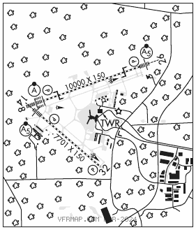
RWY 08–26: H10000X150 (CONC–GRVD) S–120, D–250, 2S–175, 2D–485, 2D/2D2–1005 PCN 76 R/B/W/T HIRL CL
RWY08: ALSF2. TDZL. PAPI(P4L)–GA 3.0° TCH 70′. RVR–TMR Trees.
RWY 26: MALSR. TDZL. PAPI(P4R)–GA 3.0° TCH 70′. RVR–TMR
RWY 14–32: H7701X150 (CONC–GRVD) S–120, D–250, 2S–175, 2D–480, 2D/2D2–1000 PCN 88 R/C/W/T HIRL CL
RWY 14: MALSR. TDZL. PAPI(P4L)–GA 3.0° TCH 70′. Trees.
RWY 32: REIL. PAPI(P4L)–GA 3.0° TCH 67′. Trees.
ARRESTING GEAR/SYSTEM
RWY 08 BAK–14 BAK–12B(B) (1537 FT). BAK–14 BAK–12B–(B) (1612 FT) RWY 26
SERVICE: S3 FUEL 100LL, JET A MILITARY–A–GEAR BAK–12B(B)/14 raised by twr O/R. A–G not inspected or certified on Sat, Sun and Mon. For further info ctc FANG Comd Post C904–741–7125. JASU (AM32A–60) 3(A/M32A–86) FUEL J8 (Mil) A, A+ (C904–741–0904, 4 hr PN.) (NC–100LL) FLUID LPOX LOX SP OIL O–148 (Mil) SOAP
AIRPORT REMARKS: Attended continuously. Bird act invof arpt, wildlife presently on afld. Radio ctld acft act 3.5 NM north–northwest of arpt. Small portion of terminal ramp not visible from twr. Ctl twr unable to determine if ramp is clear. PPR 24 hrs for unscheduled air carrier ops with more than 30 pax seats call arpt mgr 904–741–2020. PPR for high pwr jet engine run ups ctc arpt ops at 904–741–2000. Arpt CLOSED to acft wingspan more than 171′ exc 6 hr PPR 904–741–2020. All acft with wingspan greater than 118′ must perform judgemental oversteering instead of cockpit over centerline steering when taxiing. Arpt clsd to intl general aviation arr exc 6 hr PPR arpt ops at 904–741–2020 and ctc U.S. CSTMS and svcg FBO for processing and instr. Non–load bearing asph on west air carrier ramp btn outer high mast lgts and terminal. BAK 14 cable raised for tailhook engagement by twr on pilot req only. 1537′ from AER 08 and 1612′ from AER 26. Acft rqrd to maintain taxi ops over cntrln on the air carrier ramp.
AIRPORT MANAGER: (904) 741-3866
WEATHER DATA SOURCES: ASOS 125.85 (904) 741–4304. LLWAS. WSP.
COMMUNICATIONS: D–ATIS 125.85 UNICOM 122.95
®APP/DEP CON 121.3 (Abv 6,000′) 124.9 (091°–180°, 5,000′ & blo) 127.0 (270°–090°) 127.775 (181°–269°) 132.775 (091°–180° abv 5,000′) 119.0 (270°–090°)
TOWER 118.3 GND CON 121.9 CLNC DEL 119.5
CPDLC (LOGON KUSA)
PDC
AIRSPACE: CLASS C svc ctc APP CON.
VOR TEST FACILITY (VOT) 111.0
RADIO AIDS TO NAVIGATION: NOTAM FILE CRG.
CRAIG (H) (H) VORTACW 114.5 CRG Chan 92 N30°20.33′ W81°30.60′ 318° 13.1 NM to fld. 42/3W.
DINNS NDB (HW/LOM) 344 JA N30°27.90′ W81°48.10′ 080° 6.2 NM to fld. 18/6W. NOTAM FILE JAX.
ILS 110.7 I–JAX Rwy 08. Class IIIE. LOM DINNS NDB.
ILS 110.5 I–CZH Rwy 14. Class IB. Autopilot cpd apch NA blw 750′ MSL.
ILS 110.3 I–PEK Rwy 26. Class IA. LOC unusable byd 28° left of course.