LONG ISLAND MAC ARTHUR (ISP)(KISP) P (ARNG) 40 E UTC–5(–4DT) N40°47.77′
W73°06.04′ 99 B LRA Class I, ARFF Index C NOTAM FILE ISP
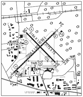
RWY 06–24: H7006X150 (ASPH–GRVD) S–100, D–210, 2S–175, 2D–300 PCN 55 F/B/X/U HIRL CL
RWY 06: MALSR. PAPI(P4L)–GA 3.0° TCH 53′. RVR–TR Tree.
RWY 24: MALSR. PAPI(P4L)–GA 3.0° TCH 52′. RVR–TR Rgt tfc.
RWY 15R–33L: H5186X150 (ASPH–GRVD) S–100, D–170, 2S–175, 2D–300 PCN 55 F/B/X/U MIRL 0.4% up NW
RWY 15R: PAPI(P4L)–GA 3.1° TCH 46′. Rgt tfc.
RWY 33L: PAPI(P4L)–GA 3.0° TCH 50′. Trees.
RWY 15L–33R: H3175X75 (ASPH) S–25 PCN 19 F/B/X/U 0.3% up NW
RWY 33R: Rgt tfc.
LAND AND HOLD–SHORT OPERATIONS
LDG RWY HOLD–SHORT POINT AVBL LDG DIST
RWY 06 15R–33L 4200
RWY 33R 06–24 3000
RUNWAY DECLARED DISTANCE INFORMATION
RWY 06: TORA–7006 TODA–7006 ASDA–7006 LDA–7006
RWY 15L:TORA–3175 TODA–3175 ASDA–3175 LDA–3175
RWY 15R:TORA–5186 TODA–5186 ASDA–5186 LDA–5186
RWY 24: TORA–7006 TODA–7006 ASDA–7006 LDA–7006
RWY 33L:TORA–5186 TODA–5186 ASDA–5186 LDA–5186
RWY 33R:TORA–3175 TODA–3175 ASDA–3175 LDA–3175
SERVICE: S4 FUEL 100LL, JET A OX 1, 2, 3, 4 LGT Dusk–dawn. When ATCT clsd ACTVT MIRL Rwy 15R–33L; twy lgts–CTAF. HIRL Rwy 06–24 preset low intst ACTVT–CTAF. MALSR Rwy 06 or 24 preset med intst for prevailing wind rwy. Rwy 06 nstd MALSR, three outermost flasher lgts exceed std spacing. MILITARY– FUEL 100LL, A
NOISE: Voluntary noise abatement procedures in effect for fixed wing acft and helicopters. Ctc arpt management 631–467–3300.
AIRPORTREMARKS:Attended continuously. Bird activity on and invof arpt. Advsy, tfc ldg Rwy 33L high density VFR tfc opr 600′ MSL and blo vcnty Bayport Aerodrome 3 miles southeast. Updrafts may be encountered invof powerplant 1.5 NM northeast Rwy 24. Rwy 15L–33R clsd to fixed wing acft at ngt and avbl for taxiing. Rwy 15L–33R not avbl for ngt tkf and ldg ops. Ltd to 48,000 lbs or less. Rwy 15L–33R clsd to sked acr ops more than 9 pax seats and non sked acr ops more than 30 pax seats. Twy S unlgtd east of terminal apron. Rwy 15L nstd markings, thld bar missing on rwy end. Rwy 33R nstd markings, thld bar missing on rwy end. Ldg fee for all acft exc mil, govt and not–for–profit medical flights.
AIRPORT MANAGER: 631-467-3300
WEATHER DATA SOURCES: ASOS 120.725 (631) 471–0131. WSP.
COMMUNICATIONS: CTAF 119.3 ATIS 120.725 UNICOM 122.95
®NEW YORK APP/DEP CON 120.05
LONG ISLAND TOWER 119.3 (1100–0500Z‡) GND CON 135.3 CLNC DEL 121.85
CLEARANCE DELIVERY PHONE: For CD when ATCT clsd ctc New York Apch at 516-683-2449.
AIRSPACE: CLASS C svc ctc APP CON svc 1100–0500Z‡; other times CLASS E.
VOR TEST FACILITY (VOT) 109.4
RADIO AIDS TO NAVIGATION: NOTAM FILE ISP.
DEER PARK (L) (L) VORW/DME 117.7 DPK Chan 124 N40°47.50′ W73°18.22′ 100° 9.3 NM to fld. 123/12W.
VOR/DME unusable:
Byd 25 NM blo 5,000′
DME unusable:
265°–274° byd 17 NM blo 5,000′
275°–280°
281°–015° byd 17 NM blo 5,000′
LOKKS NDB (LOMW) 366 IS N40°43.74′ W73°11.41′ 059° 5.7 NM to fld. 12/14W.
ILS/DME 108.3 I–ISP Chan 20 Rwy 06. Class IIE. LOM LOKKS NDB. Unmonitored when ATCT clsd. LOC unusable byd 22° left of course.
ILS 108.3 I–RXN Rwy 24. Class IT. Unmonitored when ATCT clsd. Autopilot cpd apch na blw 800′.
• • • • • • • • • • • • • • • • • •
HELIPAD H1: H50X50 (ASPH)
HELIPAD H2: H50X50 (ASPH)
HELIPORT REMARKS: Helipad H1 lctd on Twy W south of the int of Twy B. Helipad H2 lctd on Twy C north of Twy S.