WILLIMANTIC
WINDHAM (IJD)(KIJD) 3 NE UTC–5(–4DT) N41°44.64′ W72°10.81′ 246 B NOTAM FILE IJD
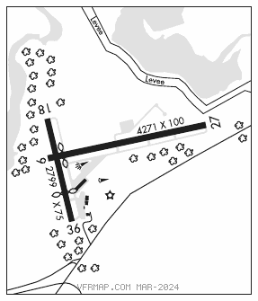
RWY 09–27: H4271X100 (ASPH) S–30 MIRL
RWY 09: Thld dsplcd 258′. Trees.
RWY 27: REIL. Tree.
RWY 18–36: H2799X75 (ASPH) S–30 0.4% up S
RWY 18: Trees.
RWY 36: Thld dsplcd 799′. Trees.
SERVICE: S4 FUEL 100LL, JET A+ LGT ACTIVATE REIL Rwy 27; MIRL Rwy 09–27–CTAF.
AIRPORT REMARKS: Unattended. Self svc fuel credit card only. Jet A has ovr wing and sngl point nozzles. Birds on and invof arpt. 4 obstruction lgts on surrounding hills OTS indef. Ldg fee for business/corporate acft.
AIRPORT MANAGER: 860-982-2443
WEATHER DATA SOURCES: ASOS 133.675 (860) 456–8839.
COMMUNICATIONS: CTAF/UNICOM 122.975
®BRADLEY APP/DEP 127.8
®BOSTON CENTER APP CON 124.85 (Sun–Fri 0530–1030Z‡, Sat 0500–1030Z‡)
CLNC DEL 128.6
CLEARANCE DELIVERY PHONE: For CD ctc Yankee Apch at 860-386-3597.
RADIO AIDS TO NAVIGATION: NOTAM FILE BDR.
NORWICH (L) (L) VORW/DME 110.0 ORW Chan 37 N41°33.38′ W71°59.96′ 338° 13.9 NM to fld. 31014W.
LOC/DME 108.35 I–IJD Chan 20(Y) Rwy 27. LOC unusable byd 20° right and left side of course. DME unusable byd 12 NM.