GEORGE BUSH INTCNTL/HOUSTON (IAH)(KIAH) 15 N UTC–6(–5DT) N29°59.07′
W95°20.49′ 96 B LRA Class I, ARFF Index E NOTAM FILE IAH
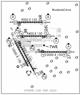
RWY 15L–33R: H12001X150 (CONC–GRVD) S–100, D–200, 2S–175, 2D–400, 2D/2D2–800 PCN 72 R/A/W/T HIRL CL
RWY 15L: PAPI(P4R)—GA 3.0° TCH 58′. RVR–TMR
RWY 33R: MALSR. RVR–TMR
RWY 09–27: H10000X150 (CONC–GRVD) D–210, 2S–175, 2D–560 PCN 67 R/A/W/T HIRL CL
RWY 09: MALSR. PAPI(P4R)—GA 3.0° TCH 71′. RVR–TMR
RWY 27: ALSF2. TDZL. PAPI(P4L)—GA 3.0° TCH 70′. RVR–TMR
RWY 15R–33L: H10000X150 (CONC–GRVD) S–75, D–200, 2S–175, 2D–400, 2D/2D2–873 PCN 94 R/B/W/T HIRL CL
RWY 15R: MALSR. TDZL. PAPI(P4L)—GA 3.0° TCH 71′. RVR–TMR
RWY 33L: TDZL. PAPI(P4R)—GA 3.0° TCH 59′. RVR–TMR
RWY 08R–26L: H9402X150 (CONC–GRVD) S–75, D–210, 2S–175, 2D–498, 2D/2D2–873 PCN 72 R/A/W/T HIRL CL
RWY 08R: MALSR. TDZL. PAPI(P4L)—GA 3.0° TCH 72′. RVR–TMR
RWY 26L: ALSF2. TDZL. PAPI(P4R)—GA 3.0° TCH 71′. RVR–TMR
RWY 08L–26R: H9000X150 (CONC–GRVD) S–75, D–210, 2S–175, 2D–409, 2D/2D2–873 PCN 72 R/A/W/T HIRL CL
RWY 08L: ALSF2. TDZL. RVR–TMR
RWY 26R: ALSF2. TDZL. RVR–TMR
LAND AND HOLD–SHORT OPERATIONS
LDG RWY HOLD–SHORT POINT AVBL LDG DIST
RWY 08R TWY NP 9019
RWY 26L TWY NE 9010
RUNWAY DECLARED DISTANCE INFORMATION
RWY 08L:TORA–9000 TODA–9000 ASDA–9000 LDA–9000
RWY 08R:TORA–9402 TODA–9402 ASDA–9402 LDA–9402
RWY 09: TORA–10000 TODA–10000 ASDA–10000 LDA–10000
RWY 15L:TORA–12001 TODA–12001 ASDA–12001 LDA–12001
RWY 15R:TORA–10000TODA–10000 ASDA–10000 LDA–10000
RWY 26L:TORA–9402 TODA–9402 ASDA–9402 LDA–9402
RWY 26R:TORA–9000 TODA–9000 ASDA–9000 LDA–9000
RWY 27: TORA–10000 TODA–10000 ASDA–10000 LDA–10000
RWY 33L:TORA–10000 TODA–10000 ASDA–10000 LDA–10000
RWY 33R:TORA–12001TODA–12001 ASDA–12001 LDA–12001
SERVICE: S4 FUEL 100LL, JET A OX 2
NOISE: Noise sensitive area north, east and west of arpt.
AIRPORT REMARKS: Attended continuously. Birds on and invof arpt. Wildlife haz bats invof IAH. Rwy 09–27 clsed to acft with wingspan 215′ and above. ASDE–X in use. Opr transponders with altitude reporting mode and ADS–B (if equipped) enabled on all airport surfaces. Acft equipped with dual antennas should use top antenna. GBAS apch svc vol 20 NM fr thld, all GLS apchs. Rwy status lgts are in opn. Rwy 15L–33R magnetic anomalies may affect compass hdg for tkof. North ramp north and south taxilanes clsd to acft with wing spans greater than 125′. Taxilane RC clsd to acft with wingspan greater than 135′. Twy NR clsd to acft with wing spans greater than 125′ between Twy WD and Twy WB. Twy NR btn Twy NC and Twy WW clsd to acft wingspan more than 214. Twy SF btn Rwy 09–27 up to and including the east bridge clsd to acft with wingspan 215′ and over. Twy WW run–up pad for Rwy 15L clsd acft with wingspan 135′ and over. Twy WW btn Twy NR and Twy WB clsd to acft wingspan more than 214′. Pilots and crews should be aware of dep turns on crs in excess of 180°. Pilot readback of direction of turns is highly encouraged. The flwg mov areas are not vsb fm the ATCT: portions of Twys WA and WB fm Twy WH to the AER 33R; Twys WA and WB fm Twy WD north for 400′; Twy WD fm Twy WA to Twy NR; Twy NR; Twy WL fm Rwy 15L to Twy WB and Twy WM. Taxilane RA, RB, RC, R2, and Twy SC north of Twy SB are designated non–movement areas operated by UAL ramp ctl. Twy SF btn Twy NB and Txl RA is dsgnd non–mov area. Dual twy ops Twy NK btn Twy NB and North Ramp, west cntrln rstd to acft max wing spans 125′ and east cntrln max wing spans 214′. Twy NR btn Twy WW and WB is designated non–movement area. Twy NK btn Twy NB and terminal D ramp simultaneous acft ops prohibited when middle taxilane in use. Twy WC west of Rwy 15R–33L rstrd to acft with 118′ wingspan and blw. Twy WA and Twy WB magnetic anomalies may affect compass hdg. Twy NA lgt all between Twy WP and Twy NP not standard. 9′ AGL unmarked security fence adjacent to FBO and corporate base operator ramps and non–movement area taxilanes. Ldg fee. Flight Notification Service (ADCUS) available. Apron terminal alpha north ramp north–south txl clsd to acft wingspan more 125 ft. Apron terminal alpha north ramp spot 5 clsd to acft wingspan more than 118 ft. Apron terminal alpha north ramp east–west txl clsd to acft wingspan more than 118 ft. Apron terminal alpha north ramp spot 6 clsd to acft wingspan more than 125 ft. Twy WD btn Twy NR and Twy WB clsd to acft wingspan more than 171′. Twy NJ btn Twy NB and Terminal C Ramp simultaneous acft ops prohibited when middle taxilane in use, middle taxilane clsd to acft wingspn more than 214′. Dual twy opns Twy NJ btn Twy NB and Terminal C ramp; west cntrln rstrd to acft max wing spans 118′ and east cntrln max wing spans 118′.
AIRPORT MANAGER: 281-233-1131
WEATHER DATA SOURCES: ASOS (281) 443–6397 TDWR.
COMMUNICATIONS: D–ATIS 124.05 (281–209–8665) UNICOM 122.95
HOUSTON RCO 122.4 (MONTGOMERY COUNTY RADIO)
®HOUSTON APP CON 124.35 (West) 120.05 (East)
®HOUSTON DEP CON 123.8 (West) 119.7 (North) 127.125
TOWER 135.15 (Rwy 09 and Rwy 27) 127.3 (Rwy 15R–33L and Rwy 15L–33R) 125.35 (Rwy 08R and Rwy 26L) 120.725 (Rwy 08L and Rwy 26R) GND CON 121.7 (Rwy 15L–33R, and Rwy 15R–33L ) 118.575 (Rwy 08L–26R, Rwy 08R–26L and Rwy 09–27)
GND METERING 119.95 CLNC DEL 128.1
CPDLC (LOGON KUSA)
PDC
AIRSPACE: CLASS B See VFR Terminal Area Chart.
RADIO AIDS TO NAVIGATION: NOTAM FILE IAH.
HUMBLE (H) (H) VORTACW 116.6 IAH Chan 113 N29°57.42′ W95°20.74′ 003° 1.7 NM to fld. 81/5E. VORTAC monitored by ATCT
VOR portion unusable:
060°–070° byd 35 NM
175°–185° byd 20 NM blo 3,000′
Byd 30 NM blo 2,000′
DME unusable:
015°–090° byd 30 NM blo 2,000′
130°–320° byd 30 NM blo 2,000′
175°–185° byd 20 NM blo 3,000′
230°–250°
TACAN AZIMUTH unusable:
040°–055° blo 5,000′
150°–320° blo 4,500′
150°–320° byd 10 NM
ILS/DME 111.55 I–BZU Chan 52(Y) Rwy 08L. Class IIIE.
ILS/DME 109.7 I–IAH Chan 34 Rwy 08R. Class IE. DME also serves Rwy 26.
ILS/DME 110.9 I–UYO Chan 46 Rwy 09. DME also serves Rwy 27.
ILS 111.15 I–LKM Rwy 15R. Class IE. LOC unusable byd 30° right of course. DME unusable byd 25° left of course.
ILS/DME 109.7 I–JYV Chan 34 Rwy 26L. Class IIIE. DME also serves Rwy 08.
ILS/DME 111.55 I–OND Chan 52(Y) Rwy 26R. Class IIIE.
ILS/DME 110.9 I–GHI Chan 46 Rwy 27. Class IIIE. DME also serves Rwy 09.
ILS 111.9 I–CDG Rwy 33R. Class IE.