SHIRLEY
BROOKHAVEN (HWV)(KHWV) 1 N UTC–5(–4DT) N40°49.32′ W72°52.01′ 81 B NOTAM FILE HWV
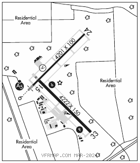
RWY 15–33: H4222X150 (ASPH–CONC) S–52, D–70, 2S–89, 2D–120 MIRL
RWY 15: REIL. PAPI(P2L)–GA 3.0° TCH 47′. Trees.
RWY 33: REIL. PAPI(P2L)–GA 3.0° TCH 46′. Trees.
RWY 06–24: H4201X100 (ASPH) S–32, D–56, 2D–93 MIRL 0.3% up NE
RWY 06: MALSR. VASI(V4L)–GA 3.0° TCH 47′. Trees.
RWY 24: REIL. Trees.
SERVICE: S4 FUEL 100LL, JET A LGT All twy lgts opr. Actvt MALSR Rwy 06; REIL Rwys 24, 15 and 33; PAPI Rwys 15 and 33; MIRL Rwys 06–24 and 15–33–CTAF. Rwy 06 VGSI and glidepath not coincident.
AIRPORT REMARKS: Attended 1200–0000Z‡. Parachute Jumping. Deer all areas of arpt especially at ngt. Extensive parachute jumping activity invof arpt. Upper air balloons launched 3 miles north of arpt 1100Z‡ and 2300Z‡. Glider ops dalgt hrs. Pilots be aware when conducting practice ILS apchs, extensive lgt acft training on and invof arpt all hrs. Gliders use rgt tfc pat for Rwy 24 and Rwy 33, gliders use left tfc pat for Rwy 06 and Rwy 15. TGL on hol, wkends and non–dalgt hrs not rcmdd. Relocated thld is Taxiway Z1. Overnight ramp parking $5.00. Landing fees vary. See arpt website for more info.
AIRPORT MANAGER: 631-451-6299
WEATHER DATA SOURCES: ASOS 119.625 (631) 399–7095.
COMMUNICATIONS: CTAF/UNICOM 122.8
®NEW YORK APP/DEP CON 120.05
CLNC DEL 133.2
CLEARANCE DELIVERY PHONE: For CD ctc New York Apch at 516-683-2449 or 133.2
RADIO AIDS TO NAVIGATION: NOTAM FILE ISP.
CALVERTON (L) (H) VORW/DME 114.55 CCC Chan 92(Y) N40°55.78′ W72°47.93′ 219° 7.2 NM to fld. 85/13W.
VOR unusable:
055°–075°
233°–268° byd 25 NM
269°–290°
DME unusable:
056°–066° byd 39 NM
ILS 108.95 I–HWV Rwy 06. Glideslope unmonitored. LOC unusable byd 4.6 NM fm thld abv 2,100′. LOC unusable within thld abv 1,000′. LOC unusable within 0.5 NM.