WILLIAM P HOBBY (HOU)(KHOU) 8 SE UTC–6(–5DT) N29°38.75′ W95°16.63′
46 B LRA Class I, ARFF Index C NOTAM FILE HOU
RWY 04–22: H7602X150 (CONC–GRVD) S–75, D–200, 2S–168, 2T–461, 2D–400, 2D/D1–444, C5–717 HIRL CL
RWY 04: ALSF2. TDZL. PAPI(P4R)—GA 3.0° TCH 58′. RVR–TMR
RWY 22: MALS. PAPI(P4L)—GA 3.0° TCH 49′. RVR–TMR Pole.
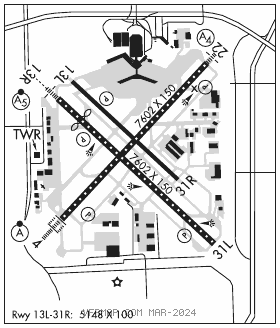
RWY 13R–31L: H7602X150 (ASPH–GRVD) S–75, D–195, 2S–168, 2T–461, 2D–220, 2D/D1–444, C5–717 HIRL CL
RWY 13R: MALSR. TDZL. PAPI(P4R)—GA 3.0° TCH 52′. RVR–T Thld dsplcd 1034′. Pole.
RWY 31L: TDZL. REIL. PAPI(P4L)—GA 3.0° TCH 76′. RVR–T Road.
RWY13L–31R:H5148X100 (CONC–GRVD) S–30, D–45, 2D–80 MIRL
RWY 13L: PAPI(P4L)—GA 3.0° TCH 60′.
RUNWAY DECLARED DISTANCE INFORMATION
RWY 04: TORA–7602 TODA–7602 ASDA–7602 LDA–7602
RWY 13L:TORA–5148 TODA–5148 ASDA–5148 LDA–5148
RWY 13R:TORA–7602 TODA–7602 ASDA–7602 LDA–6568
RWY 22: TORA–7602 TODA–7602 ASDA–7602 LDA–7602
RWY 31L:TORA–7602 TODA–7602 ASDA–7602 LDA–7602
RWY 31R:TORA–5148 TODA–5148 ASDA–5148 LDA–5148
SERVICE: S2 FUEL 100LL, JET A, A1 OX 1, 2, 3, 4
AIRPORT REMARKS: Attended continuously. Numerous birds on and invof arpt. Arpt clsd to acft with wing span over 125 ft excp 24 hrs PPR call opns 713–417–5710. ASDE–X in use. Opr transponders with alt rprtg mode and ADS–B (if equipped) enabled on all arpt sfcs. Pilots/crew should be aware of dep turns in excess of 180 degs. Read back of drctn of turns is highly encouraged. Cust ramp has mult obstns; large acft will be asgnd an altn area by ATCT. Acft in tkof ptn on Rwy 22 be alert for poss radio intfc or null on freq 118.7. Use upper ant if so equipped. Twy G cntrln to parked acft on west side only 68′. Twy G cntrln to edge of adjacent svc veh road on west side only 48′. Due to complex rwy confign; when tax to thrs 13L and 13R check compass hdg bfr departing. Acft southbound on Twy C to Rwy 31L thr use extreme care; Twy C makes a 45 deg dogleg to the left xng Twy K.
AIRPORT MANAGER: 713-845-6555
WEATHER DATA SOURCES: ASOS (713) 847–1462 TDWR.
COMMUNICATIONS: D–ATIS 124.6 (713) 847–1491 UNICOM 122.95
HOBBY RCO 122.2 (MONTGOMERY COUNTY RADIO)
®HOUSTON APP CON 119.175 119.625 134.45 (South) 124.35 (West) 120.05 (East)
®HOUSTON DEP CON 134.45 (South) 123.8 (West) 119.7 (North)
HOBBY TOWER 118.7
HOUSTON GND CON 121.9 CLNC DEL 125.45 PRE–TAXI CLNC 125.45
CPDLC (LOGON KUSA)
PDC
AIRSPACE: CLASS B See VFR Terminal Area Chart.
VOR TEST FACILITY (VOT) 108.4
RADIO AIDS TO NAVIGATION: NOTAM FILE IAH.
HUMBLE (H) (H) VORTACW 116.6 IAH Chan 113 N29°57.42′ W95°20.74′ 164° 19.0 NM to fld. 81/5E. VORTAC monitored by ATCT
VOR portion unusable:
060°–070° byd 35 NM
175°–185° byd 20 NM blo 3,000′
Byd 30 NM blo 2,000′
DME unusable:
015°–090° byd 30 NM blo 2,000′
130°–320° byd 30 NM blo 2,000′
175°–185° byd 20 NM blo 3,000′
230°–250°
TACAN AZIMUTH unusable:
040°–055° blo 5,000′
150°–320° blo 4,500′
150°–320° byd 10 NM
ILS/DME 109.9 I–HUB Chan 36 Rwy 04. Class IIIE. DME also serves Rwy 22.
ILS/DME 111.3 I–PRQ Chan 50 Rwy 13R. Class IE. DME also serves Rwy 31L.
LOC/DME 109.9 I–OIB Chan 36 Rwy 22. DME also serves Rwy 04. DME unusable byd 34° left of course.
ILS/DME 111.3 I–UPU Chan 50 Rwy 31L. Class IE. DME also serves Rwy 13R.